Galatia Channel:Dykersburg (Shale) Member: Difference between revisions
Alan.Myers (talk | contribs) |
Alan.Myers (talk | contribs) No edit summary |
||
| (31 intermediate revisions by 2 users not shown) | |||
| Line 1: | Line 1: | ||
{{ | {{Infobox_links/Stratigraphy}} | ||
==Dykersburg (Shale) Member== | ==Dykersburg (Shale) Member== | ||
===Definition=== | ===Definition=== | ||
Hopkins (1968) | Hopkins (1968)<ref name=":0">Hopkins, M.E., 1968, Harrisburg (No. 5) Coal reserves of southeastern Illinois: Illinois State Geological Survey, Circular 431, 25 p., 2 pl.</ref> assigned the name Dykersburg Shale ([[:File:C605-Figure-04.jpg|Figure 4]]) to the unit of gray clastic strata that lies between the Springfield Coal and Turner Mine Shale. As discussed here, the Dykersburg comprises a variety of rock types, ranging from true fissile shale to weakly fissile, laminated, and massive mudstone, siltstone, and sandstone. On this basis, the name “Dykersburg Member” seems more appropriate than “Dykersburg Shale.” However, the latter term has been used by nearly all previous authors. | ||
<div><ul> | <center><div><ul> | ||
<li style="display: inline-block;">[[File: | <li style="display: inline-block;">[[File:C605-Figure-04.jpg|500px|{{File:C605-Figure-04.jpg}}|thumb]]</li> | ||
</ul></div> | </ul></div></center> | ||
Chronologically, the Dykersburg is younger than the Springfield Coal, and younger than the Galatia Member and the channels it fills. Cores and exposures in underground mines show the Dykersburg in erosive contact with the Galatia Member. However, the Galatia and Dykersburg Members contain similar rock types and are difficult to distinguish in well logs other than cores. In addition, wedges of Dykersburg locally split the Springfield Coal and separate the coal from its underclay. This is a seeming paradox—a younger unit within and beneath an older one. The unusual processes that caused this anomaly are addressed later in this report. | Chronologically, the Dykersburg is younger than the Springfield Coal, and it is younger than the Galatia Member and the channels it fills. Cores and exposures in underground mines show the Dykersburg in erosive contact with the Galatia Member. However, the Galatia and Dykersburg Members contain similar rock types and are difficult to distinguish in well logs other than cores. In addition, wedges of Dykersburg locally split the Springfield Coal and separate the coal from its underclay. This is a seeming paradox—a younger unit within and beneath an older one. The unusual processes that caused this anomaly are addressed later in this report. | ||
===Thickness and distribution=== | ===Thickness and distribution=== | ||
The Dykersburg is closely associated with the Galatia channel. As mapped by Hopkins (1968) and Eggert (1994), the Dykersburg occupies an irregular southwest-trending belt along the Galatia channel ([[:File: | The Dykersburg is closely associated with the Galatia channel. As mapped by Hopkins (1968)<ref name=":0" /> and Eggert (1994)<ref>Eggert, D.L., 1994, Coal resources of Gibson County, Indiana: Indiana Geological Survey, Special Report 50, 36 p., 1 pl.</ref>, the Dykersburg occupies an irregular southwest-trending belt along the Galatia channel ([[:File:C605-Figure-14.jpg|Figure 14]]). This belt widens from about 9 to 12 mi (15 to 20 km) in Indiana to nearly 31 mi (50 km) in southern Illinois. Distribution of the shale relative to the channel is not symmetrical. Most of the thick shale is southeast of the channel in Indiana, whereas thick shale in southern Illinois is largely northwest of the channel. In places, the Dykersburg is missing right up to the channel margin. Maximum thickness of the Dykersburg increases from about 80 ft (24 m) in Indiana to as much as 125 ft (38 m) in Saline County, Illinois. | ||
<div><ul> | <center><div><ul> | ||
<li style="display: inline-block;">[[File: | <li style="display: inline-block;">[[File:C605-Figure-14.jpg|500px|{{File:C605-Figure-14.jpg}}|thumb]]</li> | ||
</ul></div> | </ul></div></center> | ||
Beyond areas of thick, continuous Dykersburg, the member occurs as isolated pods and lenses that are typically | Beyond areas of thick, continuous Dykersburg, the member occurs as isolated pods and lenses that are typically 3 to 10 ft (1 to 3 m) thick and several tens of feet (meters) to roughly 330 ft (100 m) across. These are known mostly from exposures in underground mines. Including these lenses, the width of the Dykersburg tract is 50 to 56 mi (80 to 90 km) along the southern outcrop. The extent of Dykersburg lenses farther north is poorly known because less underground mining has taken place there. | ||
===Lithology=== | ===Lithology=== | ||
Medium to medium-dark gray silty mudstone and fine- to coarse-grained siltstone are the most prevalent rock types. Mudstone generally shows bedding or lamination but is weakly to moderately fissile. Much of the siltstone is nearly massive. Sandstone becomes common where the Dykersburg is thickest. The sandstone is light gray and very fine to fine | Medium to medium-dark gray silty mudstone and fine-to coarse-grained siltstone are the most prevalent rock types. Mudstone generally shows bedding or lamination but is weakly to moderately fissile. Much of the siltstone is nearly massive. Sandstone becomes common where the Dykersburg is thickest. The sandstone is light gray and very fine to fine grained, occurring as laminae, lenses, interbeds, and larger lens-shaped bodies. Volumetrically minor, dark gray fissile clay-shale (no silt) is mostly confined to the basal part of the Dykersburg, in contact with the Springfield Coal. | ||
Regular bands, nodules, and small concretions of siderite are common in finer grained facies of the Dykersburg. Small pyrite nodules occur in dark, carbonaceous shale, especially near the base of the member. | Regular bands, nodules, and small concretions of siderite are common in finer grained facies of the Dykersburg. Small pyrite nodules occur in dark, carbonaceous shale, especially near the base of the member. | ||
| Line 23: | Line 23: | ||
Sedimentary structures are mostly small scale. Planar, wavy, ripple, flaser, and cross-lamination are most common. Small load casts, ball-and-pillow structures, and deformed or contorted lamination (soft-sediment deformation) also are commonly seen. No cross-bedding in sets thicker than a few centimeters has been encountered. | Sedimentary structures are mostly small scale. Planar, wavy, ripple, flaser, and cross-lamination are most common. Small load casts, ball-and-pillow structures, and deformed or contorted lamination (soft-sediment deformation) also are commonly seen. No cross-bedding in sets thicker than a few centimeters has been encountered. | ||
Much of the lamination in the Dykersburg is strongly rhythmic. Specifically, bundles of thin clay-rich laminae alternate with bundles of thicker | Much of the lamination in the Dykersburg is strongly rhythmic. Specifically, bundles of thin clay-rich laminae alternate with bundles of thicker siltor sand-rich laminae (Figures [[:File:C605-Figure-15.jpg|15]] and [[:File:C605-Figure-16.jpg|16]]). This style of lamination is diagnostic of tidal settings with neap and spring tidal cycles (Archer and Kvale 1993<ref name=":1">Archer, A.W., and E.P. Kvale, 1993, Origin of gray shale lithofacies (clastic wedges) in U.S. Midcontinent coal measures (Pennsylvanian): An alternate explanation: Geological Society of America, Special Paper 286, p. 181–192.</ref>; Archer et al. 1994<ref>Archer, A.W., H.R. Feldman, E.P. Kvale, and W.P. Lanier, 1994, Comparison of drier- to wetter-interval estuarine roof facies in the Eastern and Western Interior coal basins, USA: Palaeogeography, Palaeoclimatology, Palaeoecology, v. 106, p. 171–185.</ref>, 1995<ref>Archer, A.W., G.J. Kuecher, and E.P. Kvale, 1995, The role of tidal-velocity asymmetries in the deposition of silty tidal rhythmites (Carboniferous, Eastern Interior Coal Basin, U.S.A.): Journal of Sedimentary Research, v. 65A, p. 408–416.</ref>). We have observed examples of tidal rhythmites through most of the geographic extent of the Dykersburg and at various levels in vertical profiles of the unit. The only places where rhythmites are not developed are at the thin edges of the Dykersburg, where the member is reduced to isolated lenses. <center><div><ul> | ||
<div><ul> | <li style="display: inline-block;">[[File:C605-Figure-15.jpg|500px|{{File:C605-Figure-15.jpg}}|thumb]]</li> | ||
<li style="display: inline-block;">[[File: | <li style="display: inline-block;">[[File:C605-Figure-16.jpg|500px|{{File:C605-Figure-16.jpg}}|thumb]]</li> | ||
<li style="display: inline-block;">[[File: | </ul></div></center> | ||
</ul></div> | Large-scale (feet) inclined bedding has been encountered in underground mines close to the Galatia channel. Bedding of the Dykersburg intersects the top of the coal at angles as steep as 30°, although 15° to 20° is more usual ([[:File:C605-Figure-16.jpg|Figure 16]]). Such a structure signifies the lateral accretion of wedges of sediment. | ||
Large-scale (feet) inclined bedding has been encountered in underground mines close to the Galatia channel. Bedding of the Dykersburg intersects the top of the coal at angles as steep as 30°, although 15° to 20° is more usual ([[:File: | |||
Although sandstone occurs mostly in the upper part of the Dykersburg, it locally is found directly on the Springfield Coal. Sandstone bodies are lens shaped in cross section. Their lower contacts are erosive, truncating underlying shale and forming “rolls” in the coal (see below). Some sandstone bodies are convex upward, grading laterally to siltstone and mudstone. | Although sandstone occurs mostly in the upper part of the Dykersburg, it locally is found directly on the Springfield Coal. Sandstone bodies are lens shaped in cross section. Their lower contacts are erosive, truncating underlying shale and forming “rolls” in the coal (see below). Some sandstone bodies are convex upward, grading laterally to siltstone and mudstone. | ||
===Fossils=== | ===Fossils=== | ||
Fossil land plants are widely distributed. They are profuse and beautifully preserved in the basal layers near the Galatia channel, where the Dykersburg is thickest. Fossils are preserved as compressions; that is, they are carbonized or coalified and stand out against the gray shale matrix ([[:File: | Fossil land plants are widely distributed. They are profuse and beautifully preserved in the basal layers near the Galatia channel, where the Dykersburg is thickest. Fossils are preserved as compressions; that is, they are carbonized or coalified and stand out against the gray shale matrix ([[:File:C605-Figure-17.jpg|Figure 17]]). In many areas near the channel, fossil tree stumps occur in growth position ([[:File:C605-Figure-18.jpg|Figure 18]]). Invariably, these are rooted in the top of the Springfield Coal. Rare ''Stigmaria'' roots, with rootlets attached, have been found in the plant-rich basal part of the shale, suggesting that a few trees were able to grow during the initial stages of Dykersburg deposition. | ||
<div><ul> | <center><div><ul> | ||
<li style="display: inline-block;">[[File: | <li style="display: inline-block;">[[File:C605-Figure-17.jpg|500px|{{File:C605-Figure-17.jpg}}|thumb]]</li> | ||
<li style="display: inline-block;">[[File: | <li style="display: inline-block;">[[File:C605-Figure-18.jpg|500px|{{File:C605-Figure-18.jpg}}|thumb]]</li> | ||
</ul></div> | </ul></div></center> | ||
The only invertebrate fossils are the inarticulate brachiopod Lingula and pectenoid pelecypods, such as Dunbarella. Indicative of brackish water, these forms occur chiefly on the outer margins of the Dykersburg. Trace fossils are uncommon. The few examples we have seen are mostly from cores, in the upper part of the member. They are mostly vertical and inclined burrows, some | The only invertebrate fossils are the inarticulate brachiopod ''Lingula'' and pectenoid pelecypods, such as ''Dunbarella''. Indicative of brackish water, these forms occur chiefly on the outer margins of the Dykersburg. Trace fossils are uncommon. The few examples we have seen are mostly from cores, in the upper part of the member. They are mostly vertical and inclined burrows, some such as ''Teichichnus'' with gutter stacking. Horizontal burrows are rare; no trails or feeding traces have been observed. Root traces are non-existent, except at the top of the Dykersburg directly beneath the Briar Hill Coal. | ||
===“Rolls”=== | ===“Rolls”=== | ||
Miners apply the term “rolls” to bodies of shale, siltstone, and sandstone at or near the top of a coal seam. Rolls filled with Dykersburg Shale are prevalent close to the Galatia channel, where the Dykersburg is thick and relatively coarse grained (siltstone, interlaminated shale and sandstone). They are filled with rock identical to that overlying the coal at the same site. In map view, rolls are elongate and straight to sinuous | Miners apply the term “rolls” to bodies of shale, siltstone, and sandstone at or near the top of a coal seam. Rolls filled with Dykersburg Shale are prevalent close to the Galatia channel, where the Dykersburg is thick and relatively coarse grained (siltstone, interlaminated shale, and sandstone). They are filled with rock identical to that overlying the coal at the same site. In map view, rolls are elongate and straight to sinuous and are locally branching. Rolls commonly occur in parallel sets or swarms. In cross section, they are roughly lens shaped, with “riders” or stringers of coal overlapping one or both margins ([[:File:C605-Figure-19.jpg|Figure 19]]). Widths range from 3 to 30 ft (0.9 to 9 m), lengths from tens to hundreds of feet (meters). Similar rolls disrupt the Herrin Coal elsewhere in west-central and southern Illinois (Krausse et al. 1979<ref>Krausse, H.-F., H.H. Damberger, W.J. Nelson, S.R. Hunt, C.T. Ledvina, C.G. Treworgy, and W.A. White, 1979, Roof strata of the Herrin (No. 6) Coal Member in mines of Illinois: Their geology and stability: Illinois State Geological Survey, Illinois Minerals Note 72, 54 p.</ref>; Bauer and DeMaris 1982<ref>Bauer, R.A., and P.J. DeMaris, 1982, Geologic investigation of roof and floor strata: Longwall demonstration, Old Ben Mine No. 24: Illinois State Geological Survey, Contract/Grant Report 1982-2, 49 p.</ref>; Nelson 1983<ref>Nelson, W.J., 1983, Geologic disturbances in Illinois coal seams: Illinois State Geological Survey, Circular 530, 47 p.</ref>; DiMichele et al. 2007<ref name=":2">DiMichele, W.D., H.J. Falcon-Lang, W.J. Nelson, S.D. Elrick, and P.R. Ames, 2007, Ecological gradients within a Pennsylvanian mire forest: Geology, v. 35, no. 5, p. 415–418.</ref>). | ||
<div><ul> | <center><div><ul> | ||
<li style="display: inline-block;">[[File: | <li style="display: inline-block;">[[File:C605-Figure-19.jpg|500px|{{File:C605-Figure-19.jpg}}|thumb]]</li> | ||
</ul></div> | </ul></div></center> | ||
Rolls evidently formed during early stages of drowning and burial of the peat deposit. At least some rolls appear to have formed as tidal channels within the mud flats that developed along the flanks of drowning estuaries (e.g., DiMichele et al. 2007; Elrick et al. 2013). Currents scoured the peat, which, although tough and fibrous, was pliable and partially buoyant. Layers of peat were ripped out and clastic sediment filled the resulting voids. After burial, the roll filling compacted less than the surrounding peat, so the roll assumed a lens shape. | Rolls evidently formed during the early stages of drowning and burial of the peat deposit. At least some rolls appear to have formed as tidal channels within the mud flats that developed along the flanks of drowning estuaries (e.g., DiMichele et al. 2007<ref name=":2" />; Elrick et al. 2013<ref>Elrick, S.D., W.A. DiMichele, W.J. Nelson, and P.R. Ames, 2013, Middle Desmoinesian tidal channel log jams and roof flora indicate coal swamp-terminal vegetation dominated by ''Sigillaria'', tree and seed ferns—A Missourian assemblage: Geological Society of America, Abstracts with Programs, v. 45, no. 7, p. 300.</ref>). Currents scoured the peat, which, although tough and fibrous, was pliable and partially buoyant. Layers of peat were ripped out and clastic sediment filled the resulting voids. After burial, the roll filling compacted less than the surrounding peat, so the roll assumed a lens shape. | ||
===Coal “splits”=== | ===Coal “splits”=== | ||
Miners use the term “split” for a tabular or wedge-shaped layer of rock within a coal seam. Several types of splits occur in the Illinois Basin and have different modes of origin. Discussed | Miners use the term “split” for a tabular or wedge-shaped layer of rock within a coal seam. Several types of splits occur in the Illinois Basin and have different modes of origin. Discussed previously are the thin layers of dark shale that are interlayered with the Springfield Coal at the margins of the Galatia channel. These simply represent sediment that washed into the peat swamp. | ||
Markedly different are large splits in which the Dykersburg Member intrudes the Springfield Coal. These splits are elongate lenses and tapering wedges of clastic rock that divide the coal along bedding planes. Thickness ranges from a feather-edge to more than | Markedly different are large splits in which the Dykersburg Member intrudes into the Springfield Coal. These splits are elongate lenses and tapering wedges of clastic rock that divide the coal along bedding planes. Thickness ranges from a feather-edge to more than 30 ft (9 m), with a lateral extent of up to several hundred feet (meters) in some cases. The lithology of splits closely resembles that of the Dykersburg Member overlying the coal at the same locality. Most prevalent is medium gray, silty mudstone and siltstone, but some splits consist of very fine sandstone. The rock may be massive, or it may display indistinct horizontal to mildly contorted layering. Well-defined tidal lamination is rarely (if ever) seen. | ||
A number of features of these splits are noteworthy and significant in interpreting their origin. Although ragged stringers and fragments of coal are abundant, identifiable plant remains are rare. No upright stems or trunks have been observed or reported. Roots and paleosol features are absent (Figures [[:File: | A number of features of these splits are noteworthy and significant in interpreting their origin. Although ragged stringers and fragments of coal are abundant, identifiable plant remains are rare. No upright stems or trunks have been observed or reported. Roots and paleosol features are absent (Figures [[:File:C605-Figure-20.jpg|20]] and [[:File:C605-Figure-21.jpg|21]]). “Riders” of coal detach into the clastic layer from both above and below. In some cases, coal stringers cross the clastic split diagonally from the upper to the lower layer of coal ([[:File:C605-Figure-21.jpg|Figure 21]]). Splits of the type described here commonly occur hundreds of feet (meters) to more than 0.6 mi (>1 km) away from the Galatia channel and are surrounded by “normal” coal so that the splits lack a direct connection to the channel. <center><div><ul> | ||
<div><ul> | <li style="display: inline-block;">[[File:C605-Figure-20.jpg|500px|{{File:C605-Figure-20.jpg}}|thumb]]</li> | ||
<li style="display: inline-block;">[[File: | <li style="display: inline-block;">[[File:C605-Figure-21.jpg|500px|{{File:C605-Figure-21.jpg}}|thumb]]</li> | ||
<li style="display: inline-block;">[[File: | </ul></div></center> | ||
</ul></div> | |||
In the past, splits such as these were assumed to record clastic incursions into the swamp during the time of peat formation. Under the prevailing Mississippi Delta analogue, such splits were crevasse splays derived from breaches in natural levees along the main channel. But if clastic sediment was carried into a wetland with standing vegetation, we would expect upright stumps and other plant remains to be preserved in the lower part of the split, as they are in the basal Dykersburg at the top of the Springfield seam. Moreover, when plant growth resumed above the split, roots should have penetrated the latter. The absence of stumps, plant remains, roots, and other soil features casts doubt on splits being crevasse splays. | In the past, splits such as these were assumed to record clastic incursions into the swamp during the time of peat formation. Under the prevailing Mississippi Delta analogue, such splits were crevasse splays derived from breaches in natural levees along the main channel. But if clastic sediment was carried into a wetland with standing vegetation, we would expect upright stumps and other plant remains to be preserved in the lower part of the split, as they are in the basal Dykersburg at the top of the Springfield seam. Moreover, when plant growth resumed above the split, roots should have penetrated the latter. The absence of stumps, plant remains, roots, and other soil features casts doubt on splits being crevasse splays. | ||
As an alternative, we suggest that at least some of the siltstone splits near the Galatia channel resulted from rafting of peat layers during deposition of the Dykersburg. As rising waters drowned the peat, trapped air and self-generated gas made the upper layers buoyant. Agitated by tidal currents, upper layers floated free of their substrate, separating along weak bedding planes. Some of the floating layers drifted away, allowing sediment-laden water to enter beneath other peat rafts and deposit clastic layers. Obviously, no vegetation or roots grew in this setting. Stringers of peat could float upward, dangle downward, or occasionally cross from one floating peat mat to another. This activity could take place anywhere in the Dykersburg estuary, not being limited to margins of the channel that existed while the peat was forming. | As an alternative, we suggest that at least some of the siltstone splits near the Galatia channel resulted from rafting of peat layers during deposition of the Dykersburg. As rising waters drowned the peat, trapped air and self-generated gas made the upper layers buoyant. Agitated by tidal currents, the upper layers floated free of their substrate, separating along weak bedding planes. Some of the floating layers drifted away, allowing sediment-laden water to enter beneath other peat rafts and deposit clastic layers. Obviously, no vegetation or roots grew in this setting. Stringers of peat could float upward, dangle downward, or occasionally cross from one floating peat mat to another. This activity could take place anywhere in the Dykersburg estuary, not being limited to margins of the channel that existed while the peat was forming. | ||
===Major disturbances in coal=== | ===Major disturbances in coal=== | ||
Related to the planar “splits” are more dramatic disturbances of the Springfield Coal. In an example from the Millennium Mine in Saline County, Illinois (Figure 22), disturbed coal occupies an arcuate belt that is approximately 820 | Related to the planar “splits” are more dramatic disturbances of the Springfield Coal. In an example from the Millennium Mine in Saline County, Illinois ([[:File:C605-Figure-22.jpg|Figure 22]]), disturbed coal occupies an arcuate belt that is approximately 820 ft (250 m) wide and lies more than 0.6 mi (>1 km) west of the Galatia channel (as mapped by the absence of coal). There is no indication that the disturbance connects with the main channel. Within the disturbed area, the Springfield Coal rises abruptly, undulates strongly, and is torn asunder. The siltstone that underlies the coal within the disruption appears identical to siltstone overlying the coal. No roots or paleosol features occur below the coal in the area where it rises. Normal rooted underclay (claystone) occurs below the coal outside the disturbance. The coal splays apart both above and below, and large lenses of siltstone occur within the seam. At the crest of the disturbance, the roof is water-bearing sandstone. | ||
<center><div><ul> | |||
<li style="display: inline-block;">[[File:C605-Figure-22.jpg|500px|{{File:C605-Figure-22.jpg}}|thumb]]</li> | |||
</ul></div></center> | |||
A smaller disturbance occurs near the slope bottom in the same mine. Completely surrounded by normal coal, the disrupted area is ovoid in map view, about 100 × 260 ft (30 × 80 m). In the central part of the disturbance, the coal is torn apart and arches upward on one or both sides. As shown by the sketch ([[:File:C605-Figure-23.jpg|Figure 23]]), in one place the torn edges overlap one another by about 33 ft (10 m) as if repeated by a thrust fault, although no fault is present. The upper end of the torn seam thins markedly, suggesting that the peat (still pliable) was stretched, accounting for the overlap. | |||
<center><div><ul> | |||
<li style="display: inline-block;">[[File:C605-Figure-23.jpg|500px|{{File:C605-Figure-23.jpg}}|thumb]]</li> | |||
</ul></div></center> | |||
Similar in many respects is disrupted coal encountered in the northeast part of the Sahara No. 20 Mine, also in Saline County. A map and field sketch portray part of the major disturbance ([[:File:C605-Figure-24.jpg|Figure 24]]). The entire Springfield Coal seam is torn apart, leaving ragged terminations. The southern end of the torn coal arches up, partly overlapping the northern end. Separating the torn ends is “gray-brown, very hard massive silty mudstone or siltstone, similar to roof material” (John Nelson, field notes). Although the feature was not clearly exposed, the southern flap of coal appeared to truncate layering of the siltstone beneath. Notice on the map that the major disturbance is entirely surrounded by normal coal. Disturbances of lesser intensity lay north of the main one, surrounded on three sides by unaffected coal. These features lie several hundred feet (meters) west of the Galatia channel margin. <center><div><ul> | |||
<li style="display: inline-block;">[[File:C605-Figure-24.jpg|500px|{{File:C605-Figure-24.jpg}}|thumb]]</li> | |||
</ul></div></center> | |||
Also in Saline County, a large area of thin, absent, and disturbed coal interrupted the workings of the Dering Coal Company’s No. 2 Mine on the south side of the Galatia channel ([[:File:C605-Figure-25.jpg|Figure 25]]). The coal company drove entries across the disturbed area, and ISGS geologists Rolf Roley and Gilbert H. Cady sketched what they saw. By chance, an igneous dike intrudes into the coal at the eastern edge of the disturbance. On both margins, the coal splits against a blunt, rounded body of gray shale with “varve-like laminae” of light gray siltstone. The sketch indicates that coal and shale interfinger and that shale bedding is deformed in a manner suggesting forcible intrusion. | |||
<center><div><ul> | |||
<li style="display: inline-block;">[[File:C605-Figure-25.jpg|500px|{{File:C605-Figure-25.jpg}}|thumb]]</li> | |||
</ul></div></center> | |||
Another major disturbance was encountered in the northern workings of the Wabash underground mine in Wabash County, Illinois. Meier and Harper (1981)<ref name=":3">Meier, D., and D. Harper, 1981, Geologic discontinuities and associated mining problems encountered in the Harrisburg (No. 5) Coal Member near the contemporaneous Galatia channel in the Wabash Mine, Illinois: Illinois State Geological Survey, unpublished manuscript, 20 p., 16 figs. (available from the ISGS Library).</ref> described and illustrated the feature, supplemented by observations by ISGS geologists. Where crossed by mine entries, the disrupted area was about 656.2 ft (200 m) wide, flanked by normal coal on both sides, and lying at least 1,968.5 ft (600 m) south of the Galatia channel, as mapped by the absence of coal. Within the disturbance, the coal seam rises sharply, and the lower part is torn out in a highly irregular fashion ([[:File:C605-Figure-26.jpg|Figure 26]]). The rock that replaces and invades the coal is gray siltstone to fine-grained sandstone that is largely massive but that shows contorted lamination and contains many ragged stringers and chunks of coal. No roots or paleosol features were observed below the disrupted coal. | |||
<center><div><ul> | |||
<li style="display: inline-block;">[[File:C605-Figure-26.jpg|500px|{{File:C605-Figure-26.jpg}}|thumb]]</li> | |||
</ul></div></center> | |||
In the past, features such as these were generally interpreted as “splits” that formed when sediment was washed into the peat swamp, accompanied by currents that washed away some of the peat and perhaps an element of “slumping” to account for the observed deformation of layering. Specifically, Meier and Harper (1981, p. 14)<ref name=":3" /> invoked “wedges of fine-grained sediment, possibly a crevasse splay or overbank muds derived from the Galatia channel,” subsequently “thrown into a series of ridges and troughs, possibly by gravitational slumping on a slope formed by differential compaction.” Such models view “splitting” as contemporaneous with peat accumulation. But contemporaneous splitting cannot account for lifting the peat above its underclay, tearing it partly or entirely apart, and inserting a wedge of Dykersburg-like sediment between the coal and underclay. Explaining such geometry requires a new concept. | |||
We propose that like the small planar splits, these dramatic disruptions formed when rising water rafted large masses of peat during the early stages of Dykersburg deposition. Rafting could involve just the upper layers or the entire thickness of the peat deposit. Agitated by tidal currents, floating peat mats frequently tore apart, admitting sediment-laden water beneath the peat. In this manner, thick wedges of mudstone and siltstone could have been deposited within the seam and between the peat and the underclay. When currents stretched part of a torn peat mat, the ends of the mats could overlap. As the water level continued to rise, eventually the floating peat mats were completely encased in Dykersburg sediment. Differential compaction then deformed the sediment, perhaps squeezing some of it laterally. As an example, the major disturbance in the Wabash Mine is illustrated to show hypothetical ripping and rafting of peat ([[:File:C605-Figure-27.jpg|Figure 27]]).<center> <div><ul> | |||
<li style="display: inline-block;">[[File:C605-Figure-27.jpg|500px|{{File:C605-Figure-27.jpg}}|thumb]]</li> | |||
</ul></div></center> | |||
Smaller disturbances that are completely surrounded by “normal” coal (e.g., Millennium slope and Sahara No. 20) probably began as blisters of floating peat that eventually burst, allowing sediment to infiltrate beneath. Some of the larger disruptions, such as the one in the Dering No. 2 Mine, seem to involve tidal channels that connect directly to the main Galatia channel. | |||
===Absence of natural levees=== | |||
We have already shown that no natural levees flanked the Galatia channel while the Springfield peat was accumulating. Likewise, no levees existed during deposition of the Dykersburg Member, and this member and this unit appear to have been deposited in estuarine sedimentary environments rather than as crevasse splay deposits, as proposed by previous authors. | |||
Natural levees of the modern Mississippi Delta are seldom higher than about 6.6 ft (2 m) and are routinely overtopped by the floods that sustain them. Levees are composed of intermixed clay, silt, and sand exhibiting a variety of sedimentary structures, especially climbing ripples. These sediments are intensively rooted and burrowed, and they contain plentiful diagenetic iron carbonate (siderite) and iron oxide nodules (Coleman 1976)<ref name=":4">Coleman, J.M., 1976, Deltas, processes of deposition and models for exploration: Baton Rouge, Louisiana State University, Coastal Studies Institute, 124 p.</ref>. Inferred natural levees in Pennsylvanian rocks of eastern Kentucky likewise are mostly less than 5 ft (1.5 m) high and 500 | |||
ft (150 m) wide, although a few are larger. These comprise a poorly sorted, unevenly layered mix of claystone, siltstone, fine sandstone, and thin lenticular coal. Rooting is prevalent. Bedding typically dips gently away from the parent channels (Baganz et al. 1975<ref>Baganz, B.P., J.C. Horne, and J.C. Ferm, 1975, Carboniferous and recent Mississippi lower delta plains: A comparison: Gulf Coast Association of Geologists Transactions, v. 25, p. 183–191.</ref>; Horne et al. 1978<ref>Horne, J.C., J.C. Ferm, F.T. Caruccio, and B.P. Baganz, 1978, Depositional models in coal exploration and mine planning in the Appalachian region: American Association of Petroleum Geologists Bulletin, v. 62, no. 12, p. 2379–2411.</ref>). | |||
Abundant continuous cores and underground mine exposures in the Dykersburg Member, including the continuous profile in the Galatia Mine, show no bio-turbated strata that could be compared to modern natural levees. Crevasse splays cannot develop without natural levees. | |||
As Coleman (1976)<ref name=":4" /> explained, a crevasse splay is basically a small delta having its own distributary channels, delta front, and prodelta deposits. Crevasse splays are fan-shaped in map view and wedge-shaped in cross section. The coarsest sediments drop out close to the levee break; as the splay progrades into the bay or marsh, it develops an upward-coarsening profile. Although the Dykersburg Shale locally displays upward-coarsening sequences, in most cases the grain size is either uniform throughout the member or varies in a random fashion. | |||
===Origin of the Dykersburg Member=== | ===Origin of the Dykersburg Member=== | ||
| Line 97: | Line 109: | ||
*Large-scale clinoform bedding | *Large-scale clinoform bedding | ||
The Dykersburg occurs in narrow bands on either side of the Galatia channel. Although the pattern is intricate, the Dykersburg belt overall widens toward the southwest, resembling a funnel in map view (Hopkins 1968). The pattern is consistent with an estuary, as Archer and Kvale (1993) proposed. This estuary developed when a rapid rise of sea level drowned the coastline. The Francis Creek Shale overlying the Colchester Coal and the Energy Shale | The Dykersburg occurs in narrow bands on either side of the Galatia channel. Although the pattern is intricate, the Dykersburg belt overall widens toward the southwest, resembling a funnel in map view (Hopkins 1968)<ref name=":0" />. The pattern is consistent with an estuary, as Archer and Kvale (1993)<ref name=":1" /> proposed. This estuary developed when a rapid rise of sea level drowned the coastline. The Francis Creek Shale overlying the Colchester Coal and the Energy Shale overlying the Herrin Coal are close analogues to the Dykersburg, and they share nearly all the features listed above. Estuarine models have been proposed for both the Francis Creek (Kuecher et al. 1990<ref name=":5">Kuecher, G.J., B.G. Woodland, and F.M. Broadhurst, 1990, Evidence of deposition from individual tides and of tidal cycles from the Francis Creek Shale Member (host rock to the Mazon Creek biota), Westphalian D (Pennsylvanian), northeastern Illinois: Sedimentary Geology, v. 68, p. 211–221.</ref>; Baird 1997<ref>Baird, G.C., 1997, Paleoenvironmental setting of the Mazon Creek biota, ''in'' C.W. Shabica and A.A. Hay, eds., Richardson’s guide to the fossil fauna of Mazon Creek: Chicago, Northeastern Illinois University, p. 35–51.</ref>) and the Energy Shale (DiMichele et al. 2007<ref name=":2" />). | ||
The preservation of upright tree stumps and the packages of neap–spring tidal rhythmites indicate that Dykersburg sedimentation locally was rapid. Although we have not systematically measured and counted | The preservation of upright tree stumps and the packages of neap–spring tidal rhythmites indicate that Dykersburg sedimentation locally was rapid. Although we have not systematically measured and counted neap–spring cycles, they are commonly 0.4 to 2 in. (1 to 5 cm) thick, equating to deposition rates of about 3.3 ft (1 m) in 2 to 10 years. By analyzing rhythmites, Kuecher et al. (1990)<ref name=":5" /> determined that parts of the Francis Creek Shale were laid down at a rate of about 3.3 ft (1 m) per year. Of course, such findings do not show that the entire unit was laid down at such a pace. Overall sedimentation rates were limited by the rising base level, tectonic subsidence, and compaction of peat and clastic sediment, which together typically account for millimeters per year. However, in tidal environments, if accommodation space is available, that space can be filled rapidly. | ||
What caused the transition from the sediment-starved | What caused the transition from the sediment-starved black-water channel during peat formation to a much greater load of coarser sediment is unknown. Although no evidence is available, some Dykersburg sediment may have been transported up the estuary from offshore sources by flood tides. Alternatively, a large increase in fluvial runoff is suggested. A climate shift from ever-wet to a seasonally dry, monsoonal regime accompanied the global deglaciation that brought about sea-level rise. With long annual dry spells, less vegetation cloaked upland source areas. Therefore, the sediment load and transport in the Galatia river system dramatically increased in harmony with sea-level rise in the estuary. This process is consistent with the relationship observed between climate and sediment transport in modern tropical river systems (Cecil and Dulong 2003<ref>Cecil, C.B., and F.T. Dulong, 2003, Precipitation models for sediment supply in warm climates, in C.B. Cecil and N.T. Edgar, eds., Climate controls on stratigraphy: SEPM (Society for Sedimentary Geology), Special Publication 77, p. 21–27.</ref>; Cecil et al. 2003a<ref>Cecil, C.B., F.T. Dulong, R.A. Harris, J.C. Cobb, H.J. Gluskoter, and H. Nugroho, 2003a, Observations on climate and sediment discharge in selected tropical rivers, Indonesia, in C.B. Cecil and N.T. Edgar, eds., Climate controls on stratigraphy: SEPM (Society for Sedimentary Geology), Special Publication 77, p. 29–50, https://doi.org/10.2110/pec.03.77.0029.</ref>) and with the potential for a rapid, pulse-like rise of sea level in association with deglaciation (Archer et al. 2016)<ref>Archer, A.W., S. Elrick, W.J. Nelson, and W.A. DiMichele, 2016, Cataclysmic burial of Pennsylvanian Period coal swamps in the Illinois Basin: Hypertidal sedimentation during Gondwanan glacial melt-water pulses, ''in'' B. Tessier and J.-Y. Reynaud, eds., Contributions to modern and ancient tidal sedimentology: Proceedings of the Tidalites 2012 Conference: International Association of Sedimentologists, Special Publication 48, p. 217–231.</ref>. | ||
==Additional Reading== | |||
[[Dykersburg Shale Member]] on ILSTRAT | |||
{{Galatia Channel Page}} | {{Galatia Channel Page}} | ||
[[Has parent page::Galatia_Channel:Stratigraphy| ]] | |||
{{#set:Prev_Page=Galatia Channel:Springfield Coal}} | |||
{{#set:Next_Page=Galatia Channel:Turner Mine Shale Member}} | |||
Latest revision as of 20:53, 23 August 2023
Dykersburg (Shale) Member
Definition
Hopkins (1968)[1] assigned the name Dykersburg Shale (Figure 4) to the unit of gray clastic strata that lies between the Springfield Coal and Turner Mine Shale. As discussed here, the Dykersburg comprises a variety of rock types, ranging from true fissile shale to weakly fissile, laminated, and massive mudstone, siltstone, and sandstone. On this basis, the name “Dykersburg Member” seems more appropriate than “Dykersburg Shale.” However, the latter term has been used by nearly all previous authors.

Chronologically, the Dykersburg is younger than the Springfield Coal, and it is younger than the Galatia Member and the channels it fills. Cores and exposures in underground mines show the Dykersburg in erosive contact with the Galatia Member. However, the Galatia and Dykersburg Members contain similar rock types and are difficult to distinguish in well logs other than cores. In addition, wedges of Dykersburg locally split the Springfield Coal and separate the coal from its underclay. This is a seeming paradox—a younger unit within and beneath an older one. The unusual processes that caused this anomaly are addressed later in this report.
Thickness and distribution
The Dykersburg is closely associated with the Galatia channel. As mapped by Hopkins (1968)[1] and Eggert (1994)[2], the Dykersburg occupies an irregular southwest-trending belt along the Galatia channel (Figure 14). This belt widens from about 9 to 12 mi (15 to 20 km) in Indiana to nearly 31 mi (50 km) in southern Illinois. Distribution of the shale relative to the channel is not symmetrical. Most of the thick shale is southeast of the channel in Indiana, whereas thick shale in southern Illinois is largely northwest of the channel. In places, the Dykersburg is missing right up to the channel margin. Maximum thickness of the Dykersburg increases from about 80 ft (24 m) in Indiana to as much as 125 ft (38 m) in Saline County, Illinois.
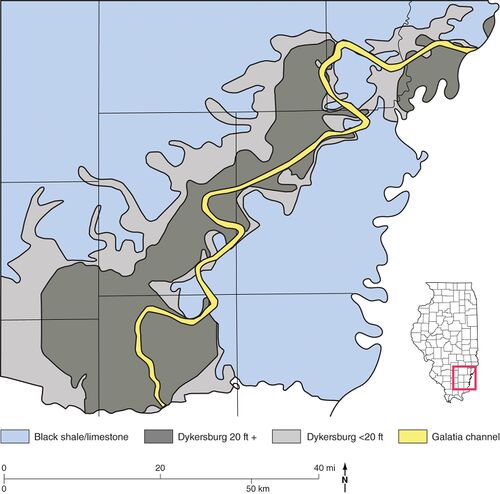 Figure 14 Map showing the thickness of the Dykersburg Member in the vicinity of Galatia channel in southeastern Illinois. From Treworgy et al. (1999)[3].

Beyond areas of thick, continuous Dykersburg, the member occurs as isolated pods and lenses that are typically 3 to 10 ft (1 to 3 m) thick and several tens of feet (meters) to roughly 330 ft (100 m) across. These are known mostly from exposures in underground mines. Including these lenses, the width of the Dykersburg tract is 50 to 56 mi (80 to 90 km) along the southern outcrop. The extent of Dykersburg lenses farther north is poorly known because less underground mining has taken place there.
Lithology
Medium to medium-dark gray silty mudstone and fine-to coarse-grained siltstone are the most prevalent rock types. Mudstone generally shows bedding or lamination but is weakly to moderately fissile. Much of the siltstone is nearly massive. Sandstone becomes common where the Dykersburg is thickest. The sandstone is light gray and very fine to fine grained, occurring as laminae, lenses, interbeds, and larger lens-shaped bodies. Volumetrically minor, dark gray fissile clay-shale (no silt) is mostly confined to the basal part of the Dykersburg, in contact with the Springfield Coal.
Regular bands, nodules, and small concretions of siderite are common in finer grained facies of the Dykersburg. Small pyrite nodules occur in dark, carbonaceous shale, especially near the base of the member.
Sedimentary structures are mostly small scale. Planar, wavy, ripple, flaser, and cross-lamination are most common. Small load casts, ball-and-pillow structures, and deformed or contorted lamination (soft-sediment deformation) also are commonly seen. No cross-bedding in sets thicker than a few centimeters has been encountered.
Much of the lamination in the Dykersburg is strongly rhythmic. Specifically, bundles of thin clay-rich laminae alternate with bundles of thicker siltor sand-rich laminae (Figures 15 and 16). This style of lamination is diagnostic of tidal settings with neap and spring tidal cycles (Archer and Kvale 1993[4]; Archer et al. 1994[5], 1995[6]). We have observed examples of tidal rhythmites through most of the geographic extent of the Dykersburg and at various levels in vertical profiles of the unit. The only places where rhythmites are not developed are at the thin edges of the Dykersburg, where the member is reduced to isolated lenses.
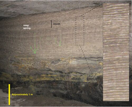 Figure 15 Photograph showing rhythmic lamination in sandy facies of the Dykersburg Member in American Coal’s Millennium Mine, Saline County, Illinois. Enlarged view at right. Reprinted from Palaeogeography, Palaeoclimatology, Palaeoecology, v. 487, p. 74, W.A. DiMichele, S.D. Elrick, and W.J. Nelson, Vegetational zonation in a swamp forest, Middle Pennsylvanian, Illinois Basin, U.S.A., indicates niche differentiation in a wetland plant community. Copyright 2017, with permission from Elsevier.


Large-scale (feet) inclined bedding has been encountered in underground mines close to the Galatia channel. Bedding of the Dykersburg intersects the top of the coal at angles as steep as 30°, although 15° to 20° is more usual (Figure 16). Such a structure signifies the lateral accretion of wedges of sediment.
Although sandstone occurs mostly in the upper part of the Dykersburg, it locally is found directly on the Springfield Coal. Sandstone bodies are lens shaped in cross section. Their lower contacts are erosive, truncating underlying shale and forming “rolls” in the coal (see below). Some sandstone bodies are convex upward, grading laterally to siltstone and mudstone.
Fossils
Fossil land plants are widely distributed. They are profuse and beautifully preserved in the basal layers near the Galatia channel, where the Dykersburg is thickest. Fossils are preserved as compressions; that is, they are carbonized or coalified and stand out against the gray shale matrix (Figure 17). In many areas near the channel, fossil tree stumps occur in growth position (Figure 18). Invariably, these are rooted in the top of the Springfield Coal. Rare Stigmaria roots, with rootlets attached, have been found in the plant-rich basal part of the shale, suggesting that a few trees were able to grow during the initial stages of Dykersburg deposition.


The only invertebrate fossils are the inarticulate brachiopod Lingula and pectenoid pelecypods, such as Dunbarella. Indicative of brackish water, these forms occur chiefly on the outer margins of the Dykersburg. Trace fossils are uncommon. The few examples we have seen are mostly from cores, in the upper part of the member. They are mostly vertical and inclined burrows, some such as Teichichnus with gutter stacking. Horizontal burrows are rare; no trails or feeding traces have been observed. Root traces are non-existent, except at the top of the Dykersburg directly beneath the Briar Hill Coal.
“Rolls”
Miners apply the term “rolls” to bodies of shale, siltstone, and sandstone at or near the top of a coal seam. Rolls filled with Dykersburg Shale are prevalent close to the Galatia channel, where the Dykersburg is thick and relatively coarse grained (siltstone, interlaminated shale, and sandstone). They are filled with rock identical to that overlying the coal at the same site. In map view, rolls are elongate and straight to sinuous and are locally branching. Rolls commonly occur in parallel sets or swarms. In cross section, they are roughly lens shaped, with “riders” or stringers of coal overlapping one or both margins (Figure 19). Widths range from 3 to 30 ft (0.9 to 9 m), lengths from tens to hundreds of feet (meters). Similar rolls disrupt the Herrin Coal elsewhere in west-central and southern Illinois (Krausse et al. 1979[7]; Bauer and DeMaris 1982[8]; Nelson 1983[9]; DiMichele et al. 2007[10]).

Rolls evidently formed during the early stages of drowning and burial of the peat deposit. At least some rolls appear to have formed as tidal channels within the mud flats that developed along the flanks of drowning estuaries (e.g., DiMichele et al. 2007[10]; Elrick et al. 2013[11]). Currents scoured the peat, which, although tough and fibrous, was pliable and partially buoyant. Layers of peat were ripped out and clastic sediment filled the resulting voids. After burial, the roll filling compacted less than the surrounding peat, so the roll assumed a lens shape.
Coal “splits”
Miners use the term “split” for a tabular or wedge-shaped layer of rock within a coal seam. Several types of splits occur in the Illinois Basin and have different modes of origin. Discussed previously are the thin layers of dark shale that are interlayered with the Springfield Coal at the margins of the Galatia channel. These simply represent sediment that washed into the peat swamp.
Markedly different are large splits in which the Dykersburg Member intrudes into the Springfield Coal. These splits are elongate lenses and tapering wedges of clastic rock that divide the coal along bedding planes. Thickness ranges from a feather-edge to more than 30 ft (9 m), with a lateral extent of up to several hundred feet (meters) in some cases. The lithology of splits closely resembles that of the Dykersburg Member overlying the coal at the same locality. Most prevalent is medium gray, silty mudstone and siltstone, but some splits consist of very fine sandstone. The rock may be massive, or it may display indistinct horizontal to mildly contorted layering. Well-defined tidal lamination is rarely (if ever) seen.
A number of features of these splits are noteworthy and significant in interpreting their origin. Although ragged stringers and fragments of coal are abundant, identifiable plant remains are rare. No upright stems or trunks have been observed or reported. Roots and paleosol features are absent (Figures 20 and 21). “Riders” of coal detach into the clastic layer from both above and below. In some cases, coal stringers cross the clastic split diagonally from the upper to the lower layer of coal (Figure 21). Splits of the type described here commonly occur hundreds of feet (meters) to more than 0.6 mi (>1 km) away from the Galatia channel and are surrounded by “normal” coal so that the splits lack a direct connection to the channel.
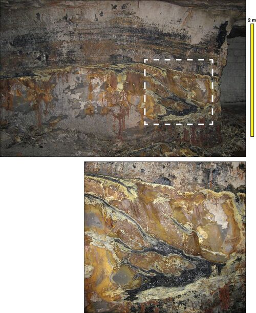 Figure 20 Photographs showing the Springfield Coal “split” by massive siltstone in the Millennium Mine. The lower view is a close-up of the upper view. Notice the ragged splaying of coal layers into the siltstone from both above and below, with one coal stringer crossing diagonally from the lower to the upper coal “bench.” Combined with the absence of roots beneath the upper bench, such geometry implies that the upper part of the peat deposit was rafted. Enlarged view at right. Brown and yellow stains resulted from iron-rich water seeping through the coal.
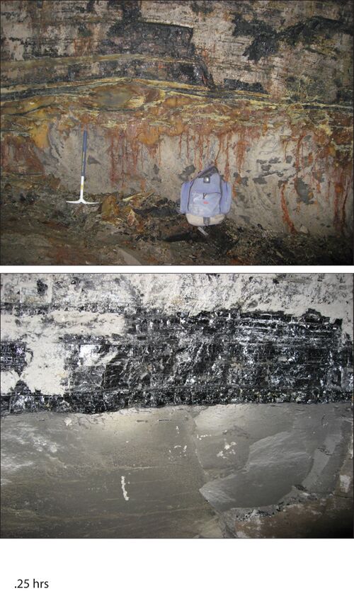 Figure 21 Photographs of siltstone “splits” in the Springfield Coal. (a) Upper “bench” of coal splitting into multiple layers, with ragged splaying of lower coal layers at the Millennium Mine. (b) Contact between the upper coal bench and a massive siltstone split in American Coal’s Millennium Mine, approximately 0.6 mi (1 km) west of the main Galatia channel. Notice the complete absence of root traces in the siltstone.


In the past, splits such as these were assumed to record clastic incursions into the swamp during the time of peat formation. Under the prevailing Mississippi Delta analogue, such splits were crevasse splays derived from breaches in natural levees along the main channel. But if clastic sediment was carried into a wetland with standing vegetation, we would expect upright stumps and other plant remains to be preserved in the lower part of the split, as they are in the basal Dykersburg at the top of the Springfield seam. Moreover, when plant growth resumed above the split, roots should have penetrated the latter. The absence of stumps, plant remains, roots, and other soil features casts doubt on splits being crevasse splays.
As an alternative, we suggest that at least some of the siltstone splits near the Galatia channel resulted from rafting of peat layers during deposition of the Dykersburg. As rising waters drowned the peat, trapped air and self-generated gas made the upper layers buoyant. Agitated by tidal currents, the upper layers floated free of their substrate, separating along weak bedding planes. Some of the floating layers drifted away, allowing sediment-laden water to enter beneath other peat rafts and deposit clastic layers. Obviously, no vegetation or roots grew in this setting. Stringers of peat could float upward, dangle downward, or occasionally cross from one floating peat mat to another. This activity could take place anywhere in the Dykersburg estuary, not being limited to margins of the channel that existed while the peat was forming.
Major disturbances in coal
Related to the planar “splits” are more dramatic disturbances of the Springfield Coal. In an example from the Millennium Mine in Saline County, Illinois (Figure 22), disturbed coal occupies an arcuate belt that is approximately 820 ft (250 m) wide and lies more than 0.6 mi (>1 km) west of the Galatia channel (as mapped by the absence of coal). There is no indication that the disturbance connects with the main channel. Within the disturbed area, the Springfield Coal rises abruptly, undulates strongly, and is torn asunder. The siltstone that underlies the coal within the disruption appears identical to siltstone overlying the coal. No roots or paleosol features occur below the coal in the area where it rises. Normal rooted underclay (claystone) occurs below the coal outside the disturbance. The coal splays apart both above and below, and large lenses of siltstone occur within the seam. At the crest of the disturbance, the roof is water-bearing sandstone.

A smaller disturbance occurs near the slope bottom in the same mine. Completely surrounded by normal coal, the disrupted area is ovoid in map view, about 100 × 260 ft (30 × 80 m). In the central part of the disturbance, the coal is torn apart and arches upward on one or both sides. As shown by the sketch (Figure 23), in one place the torn edges overlap one another by about 33 ft (10 m) as if repeated by a thrust fault, although no fault is present. The upper end of the torn seam thins markedly, suggesting that the peat (still pliable) was stretched, accounting for the overlap.

Similar in many respects is disrupted coal encountered in the northeast part of the Sahara No. 20 Mine, also in Saline County. A map and field sketch portray part of the major disturbance (Figure 24). The entire Springfield Coal seam is torn apart, leaving ragged terminations. The southern end of the torn coal arches up, partly overlapping the northern end. Separating the torn ends is “gray-brown, very hard massive silty mudstone or siltstone, similar to roof material” (John Nelson, field notes). Although the feature was not clearly exposed, the southern flap of coal appeared to truncate layering of the siltstone beneath. Notice on the map that the major disturbance is entirely surrounded by normal coal. Disturbances of lesser intensity lay north of the main one, surrounded on three sides by unaffected coal. These features lie several hundred feet (meters) west of the Galatia channel margin.

Also in Saline County, a large area of thin, absent, and disturbed coal interrupted the workings of the Dering Coal Company’s No. 2 Mine on the south side of the Galatia channel (Figure 25). The coal company drove entries across the disturbed area, and ISGS geologists Rolf Roley and Gilbert H. Cady sketched what they saw. By chance, an igneous dike intrudes into the coal at the eastern edge of the disturbance. On both margins, the coal splits against a blunt, rounded body of gray shale with “varve-like laminae” of light gray siltstone. The sketch indicates that coal and shale interfinger and that shale bedding is deformed in a manner suggesting forcible intrusion.

Another major disturbance was encountered in the northern workings of the Wabash underground mine in Wabash County, Illinois. Meier and Harper (1981)[12] described and illustrated the feature, supplemented by observations by ISGS geologists. Where crossed by mine entries, the disrupted area was about 656.2 ft (200 m) wide, flanked by normal coal on both sides, and lying at least 1,968.5 ft (600 m) south of the Galatia channel, as mapped by the absence of coal. Within the disturbance, the coal seam rises sharply, and the lower part is torn out in a highly irregular fashion (Figure 26). The rock that replaces and invades the coal is gray siltstone to fine-grained sandstone that is largely massive but that shows contorted lamination and contains many ragged stringers and chunks of coal. No roots or paleosol features were observed below the disrupted coal.
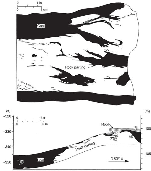 Figure 26 Drawings from Meier and Harper (1981)[13] illustrating a major disruption of the Springfield Coal in AMAX Coal’s Wabash Mine in Wabash County, Illinois.

In the past, features such as these were generally interpreted as “splits” that formed when sediment was washed into the peat swamp, accompanied by currents that washed away some of the peat and perhaps an element of “slumping” to account for the observed deformation of layering. Specifically, Meier and Harper (1981, p. 14)[12] invoked “wedges of fine-grained sediment, possibly a crevasse splay or overbank muds derived from the Galatia channel,” subsequently “thrown into a series of ridges and troughs, possibly by gravitational slumping on a slope formed by differential compaction.” Such models view “splitting” as contemporaneous with peat accumulation. But contemporaneous splitting cannot account for lifting the peat above its underclay, tearing it partly or entirely apart, and inserting a wedge of Dykersburg-like sediment between the coal and underclay. Explaining such geometry requires a new concept.
We propose that like the small planar splits, these dramatic disruptions formed when rising water rafted large masses of peat during the early stages of Dykersburg deposition. Rafting could involve just the upper layers or the entire thickness of the peat deposit. Agitated by tidal currents, floating peat mats frequently tore apart, admitting sediment-laden water beneath the peat. In this manner, thick wedges of mudstone and siltstone could have been deposited within the seam and between the peat and the underclay. When currents stretched part of a torn peat mat, the ends of the mats could overlap. As the water level continued to rise, eventually the floating peat mats were completely encased in Dykersburg sediment. Differential compaction then deformed the sediment, perhaps squeezing some of it laterally. As an example, the major disturbance in the Wabash Mine is illustrated to show hypothetical ripping and rafting of peat (Figure 27).
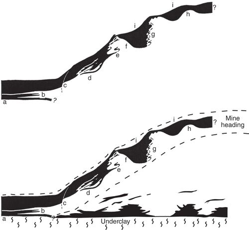 Figure 27 (Top) Image of the major disturbance in the Wabash Mine. From Meier and Harper (1981). (Bottom) The same drawing with interpretation added, depicting the peat deposit torn asunder, with the upper part floated away from the lower. The seam height at the left side of the diagram is approximately 9 ft (2.7 m).

Smaller disturbances that are completely surrounded by “normal” coal (e.g., Millennium slope and Sahara No. 20) probably began as blisters of floating peat that eventually burst, allowing sediment to infiltrate beneath. Some of the larger disruptions, such as the one in the Dering No. 2 Mine, seem to involve tidal channels that connect directly to the main Galatia channel.
Absence of natural levees
We have already shown that no natural levees flanked the Galatia channel while the Springfield peat was accumulating. Likewise, no levees existed during deposition of the Dykersburg Member, and this member and this unit appear to have been deposited in estuarine sedimentary environments rather than as crevasse splay deposits, as proposed by previous authors.
Natural levees of the modern Mississippi Delta are seldom higher than about 6.6 ft (2 m) and are routinely overtopped by the floods that sustain them. Levees are composed of intermixed clay, silt, and sand exhibiting a variety of sedimentary structures, especially climbing ripples. These sediments are intensively rooted and burrowed, and they contain plentiful diagenetic iron carbonate (siderite) and iron oxide nodules (Coleman 1976)[14]. Inferred natural levees in Pennsylvanian rocks of eastern Kentucky likewise are mostly less than 5 ft (1.5 m) high and 500
ft (150 m) wide, although a few are larger. These comprise a poorly sorted, unevenly layered mix of claystone, siltstone, fine sandstone, and thin lenticular coal. Rooting is prevalent. Bedding typically dips gently away from the parent channels (Baganz et al. 1975[15]; Horne et al. 1978[16]).
Abundant continuous cores and underground mine exposures in the Dykersburg Member, including the continuous profile in the Galatia Mine, show no bio-turbated strata that could be compared to modern natural levees. Crevasse splays cannot develop without natural levees.
As Coleman (1976)[14] explained, a crevasse splay is basically a small delta having its own distributary channels, delta front, and prodelta deposits. Crevasse splays are fan-shaped in map view and wedge-shaped in cross section. The coarsest sediments drop out close to the levee break; as the splay progrades into the bay or marsh, it develops an upward-coarsening profile. Although the Dykersburg Shale locally displays upward-coarsening sequences, in most cases the grain size is either uniform throughout the member or varies in a random fashion.
Origin of the Dykersburg Member
Many features of the Dykersburg Member point to rapid deposition in a tidal regime:
- Burial of tree stumps in the growth position
- Superb preservation of delicate plant fossils
- Sparse brackish-water invertebrate fauna
- Scarce burrowing and the absence of rooting
- Scouring of peat tops (rolls)
- Large-scale splits involving rafted peat
- Prevalent tidal rhythmites
- Common slump and load features
- Large-scale clinoform bedding
The Dykersburg occurs in narrow bands on either side of the Galatia channel. Although the pattern is intricate, the Dykersburg belt overall widens toward the southwest, resembling a funnel in map view (Hopkins 1968)[1]. The pattern is consistent with an estuary, as Archer and Kvale (1993)[4] proposed. This estuary developed when a rapid rise of sea level drowned the coastline. The Francis Creek Shale overlying the Colchester Coal and the Energy Shale overlying the Herrin Coal are close analogues to the Dykersburg, and they share nearly all the features listed above. Estuarine models have been proposed for both the Francis Creek (Kuecher et al. 1990[17]; Baird 1997[18]) and the Energy Shale (DiMichele et al. 2007[10]).
The preservation of upright tree stumps and the packages of neap–spring tidal rhythmites indicate that Dykersburg sedimentation locally was rapid. Although we have not systematically measured and counted neap–spring cycles, they are commonly 0.4 to 2 in. (1 to 5 cm) thick, equating to deposition rates of about 3.3 ft (1 m) in 2 to 10 years. By analyzing rhythmites, Kuecher et al. (1990)[17] determined that parts of the Francis Creek Shale were laid down at a rate of about 3.3 ft (1 m) per year. Of course, such findings do not show that the entire unit was laid down at such a pace. Overall sedimentation rates were limited by the rising base level, tectonic subsidence, and compaction of peat and clastic sediment, which together typically account for millimeters per year. However, in tidal environments, if accommodation space is available, that space can be filled rapidly.
What caused the transition from the sediment-starved black-water channel during peat formation to a much greater load of coarser sediment is unknown. Although no evidence is available, some Dykersburg sediment may have been transported up the estuary from offshore sources by flood tides. Alternatively, a large increase in fluvial runoff is suggested. A climate shift from ever-wet to a seasonally dry, monsoonal regime accompanied the global deglaciation that brought about sea-level rise. With long annual dry spells, less vegetation cloaked upland source areas. Therefore, the sediment load and transport in the Galatia river system dramatically increased in harmony with sea-level rise in the estuary. This process is consistent with the relationship observed between climate and sediment transport in modern tropical river systems (Cecil and Dulong 2003[19]; Cecil et al. 2003a[20]) and with the potential for a rapid, pulse-like rise of sea level in association with deglaciation (Archer et al. 2016)[21].
Additional Reading
Dykersburg Shale Member on ILSTRAT
Primary Source
References
- ↑ a b c Hopkins, M.E., 1968, Harrisburg (No. 5) Coal reserves of southeastern Illinois: Illinois State Geological Survey, Circular 431, 25 p., 2 pl.
- ↑ Eggert, D.L., 1994, Coal resources of Gibson County, Indiana: Indiana Geological Survey, Special Report 50, 36 p., 1 pl.
- ↑ Treworgy, C.G., C.P. Korose, C.A. Chenoweth, and D.L. North, 1999, Availability of the Springfield Coal for mining in Illinois: Illinois State Geological Survey, Illinois Minerals 118, 43 p.
- ↑ a b Archer, A.W., and E.P. Kvale, 1993, Origin of gray shale lithofacies (clastic wedges) in U.S. Midcontinent coal measures (Pennsylvanian): An alternate explanation: Geological Society of America, Special Paper 286, p. 181–192.
- ↑ Archer, A.W., H.R. Feldman, E.P. Kvale, and W.P. Lanier, 1994, Comparison of drier- to wetter-interval estuarine roof facies in the Eastern and Western Interior coal basins, USA: Palaeogeography, Palaeoclimatology, Palaeoecology, v. 106, p. 171–185.
- ↑ Archer, A.W., G.J. Kuecher, and E.P. Kvale, 1995, The role of tidal-velocity asymmetries in the deposition of silty tidal rhythmites (Carboniferous, Eastern Interior Coal Basin, U.S.A.): Journal of Sedimentary Research, v. 65A, p. 408–416.
- ↑ Krausse, H.-F., H.H. Damberger, W.J. Nelson, S.R. Hunt, C.T. Ledvina, C.G. Treworgy, and W.A. White, 1979, Roof strata of the Herrin (No. 6) Coal Member in mines of Illinois: Their geology and stability: Illinois State Geological Survey, Illinois Minerals Note 72, 54 p.
- ↑ Bauer, R.A., and P.J. DeMaris, 1982, Geologic investigation of roof and floor strata: Longwall demonstration, Old Ben Mine No. 24: Illinois State Geological Survey, Contract/Grant Report 1982-2, 49 p.
- ↑ Nelson, W.J., 1983, Geologic disturbances in Illinois coal seams: Illinois State Geological Survey, Circular 530, 47 p.
- ↑ a b c DiMichele, W.D., H.J. Falcon-Lang, W.J. Nelson, S.D. Elrick, and P.R. Ames, 2007, Ecological gradients within a Pennsylvanian mire forest: Geology, v. 35, no. 5, p. 415–418.
- ↑ Elrick, S.D., W.A. DiMichele, W.J. Nelson, and P.R. Ames, 2013, Middle Desmoinesian tidal channel log jams and roof flora indicate coal swamp-terminal vegetation dominated by Sigillaria, tree and seed ferns—A Missourian assemblage: Geological Society of America, Abstracts with Programs, v. 45, no. 7, p. 300.
- ↑ a b Meier, D., and D. Harper, 1981, Geologic discontinuities and associated mining problems encountered in the Harrisburg (No. 5) Coal Member near the contemporaneous Galatia channel in the Wabash Mine, Illinois: Illinois State Geological Survey, unpublished manuscript, 20 p., 16 figs. (available from the ISGS Library).
- ↑ Meier, D., and D. Harper, 1981, Geologic discontinuities and associated mining problems encountered in the Harrisburg (No. 5) Coal Member near the contemporaneous Galatia channel in the Wabash Mine, Illinois: Illinois State Geological Survey, unpublished manuscript, 20 p., 16 figs. (available from the ISGS Library).
- ↑ a b Coleman, J.M., 1976, Deltas, processes of deposition and models for exploration: Baton Rouge, Louisiana State University, Coastal Studies Institute, 124 p.
- ↑ Baganz, B.P., J.C. Horne, and J.C. Ferm, 1975, Carboniferous and recent Mississippi lower delta plains: A comparison: Gulf Coast Association of Geologists Transactions, v. 25, p. 183–191.
- ↑ Horne, J.C., J.C. Ferm, F.T. Caruccio, and B.P. Baganz, 1978, Depositional models in coal exploration and mine planning in the Appalachian region: American Association of Petroleum Geologists Bulletin, v. 62, no. 12, p. 2379–2411.
- ↑ a b Kuecher, G.J., B.G. Woodland, and F.M. Broadhurst, 1990, Evidence of deposition from individual tides and of tidal cycles from the Francis Creek Shale Member (host rock to the Mazon Creek biota), Westphalian D (Pennsylvanian), northeastern Illinois: Sedimentary Geology, v. 68, p. 211–221.
- ↑ Baird, G.C., 1997, Paleoenvironmental setting of the Mazon Creek biota, in C.W. Shabica and A.A. Hay, eds., Richardson’s guide to the fossil fauna of Mazon Creek: Chicago, Northeastern Illinois University, p. 35–51.
- ↑ Cecil, C.B., and F.T. Dulong, 2003, Precipitation models for sediment supply in warm climates, in C.B. Cecil and N.T. Edgar, eds., Climate controls on stratigraphy: SEPM (Society for Sedimentary Geology), Special Publication 77, p. 21–27.
- ↑ Cecil, C.B., F.T. Dulong, R.A. Harris, J.C. Cobb, H.J. Gluskoter, and H. Nugroho, 2003a, Observations on climate and sediment discharge in selected tropical rivers, Indonesia, in C.B. Cecil and N.T. Edgar, eds., Climate controls on stratigraphy: SEPM (Society for Sedimentary Geology), Special Publication 77, p. 29–50, https://doi.org/10.2110/pec.03.77.0029.
- ↑ Archer, A.W., S. Elrick, W.J. Nelson, and W.A. DiMichele, 2016, Cataclysmic burial of Pennsylvanian Period coal swamps in the Illinois Basin: Hypertidal sedimentation during Gondwanan glacial melt-water pulses, in B. Tessier and J.-Y. Reynaud, eds., Contributions to modern and ancient tidal sedimentology: Proceedings of the Tidalites 2012 Conference: International Association of Sedimentologists, Special Publication 48, p. 217–231.