File:Figure 11.jpg
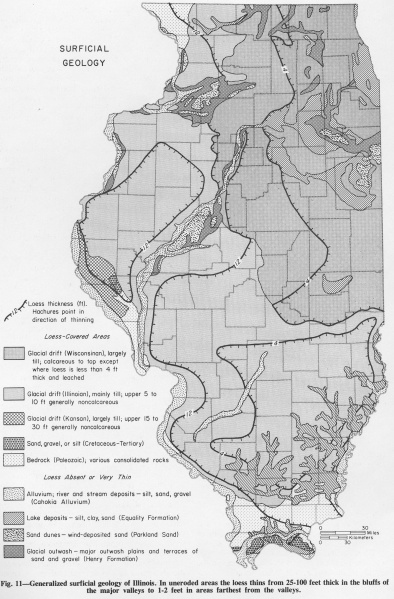
Revision as of 15:57, 1 April 2016 by Alan.Myers (talk | contribs) (Fig. 11 -- Generalized surficial geology of Illinois. In uneroded areas the loess thins from 25-100 feet thick in the bluffs of the major valleys to 1-2 feet in areas farthest from valleys.)

Size of this preview: 394 × 599 pixels. Other resolution: 2,209 × 3,358 pixels.
Original file (2,209 × 3,358 pixels, file size: 1.89 MB, MIME type: image/jpeg)
Fig. 11 -- Generalized surficial geology of Illinois. In uneroded areas the loess thins from 25-100 feet thick in the bluffs of the major valleys to 1-2 feet in areas farthest from valleys.
File history
Click on a date/time to view the file as it appeared at that time.
| Date/Time | Thumbnail | Dimensions | User | Comment | |
|---|---|---|---|---|---|
| current | ★ Approved revision 15:57, 1 April 2016 | | 2,209 × 3,358 (1.89 MB) | Alan.Myers (talk | contribs) | Fig. 11 -- Generalized surficial geology of Illinois. In uneroded areas the loess thins from 25-100 feet thick in the bluffs of the major valleys to 1-2 feet in areas farthest from valleys. |
You cannot overwrite this file.
File usage
The following 2 pages use this file: