File:C605-Figure-08.jpg: Difference between revisions
Jump to navigation
Jump to search
Alan.Myers (talk | contribs) No edit summary |
Alan.Myers (talk | contribs) No edit summary |
||
| (5 intermediate revisions by the same user not shown) | |||
| Line 1: | Line 1: | ||
{{Galatia Channel Image | {{Galatia Channel Image | ||
|File name= | |File name=C605-Figure-08.jpg | ||
|image_no=Figure 8 | |image_no=Figure 8 | ||
|caption=Map from Potter (1962), showing the thickness (in feet) of sandstone between the Houchin Creek and Springfield Coals, with the Galatia channel (from Hopkins 1968) superimposed. | |caption=Map from Potter (1962), showing the thickness (in feet) of sandstone between the Houchin Creek and Springfield Coals, with the Galatia channel (from Hopkins 1968) superimposed. | ||
|references=Potter, P.E., 1962, Shape and distribution patterns of Pennsylvanian sand bodies in Illinois: Illinois State Geological Survey, Circular 339, 36 p., 3 pls.<br> | |references=Potter, P.E., 1962, Shape and distribution patterns of Pennsylvanian sand bodies in Illinois: Illinois State Geological Survey, Circular 339, 36 p., 3 pls.<br> | ||
Hopkins, M.E., 1968, Harrisburg (No. 5) Coal reserves of southeastern Illinois: Illinois State Geological Survey, Circular 431, 25 p., 2 pl. | |||
|page1=Stratigraphy | |page1=Stratigraphy | ||
|page2=Stratigraphy/Galatia_Member | |||
|page3=Other_Channels_Related_to_the_Galatia_Channel | |||
}} | }} | ||
Revision as of 20:39, 10 July 2020
Figure 8 Map from Potter (1962), showing the thickness (in feet) of sandstone between the Houchin Creek and Springfield Coals, with the Galatia channel (from Hopkins 1968) superimposed.
File history
Click on a date/time to view the file as it appeared at that time.
| Date/Time | Thumbnail | Dimensions | User | Comment | |
|---|---|---|---|---|---|
| current | ★ Approved revision 14:28, 9 July 2020 | 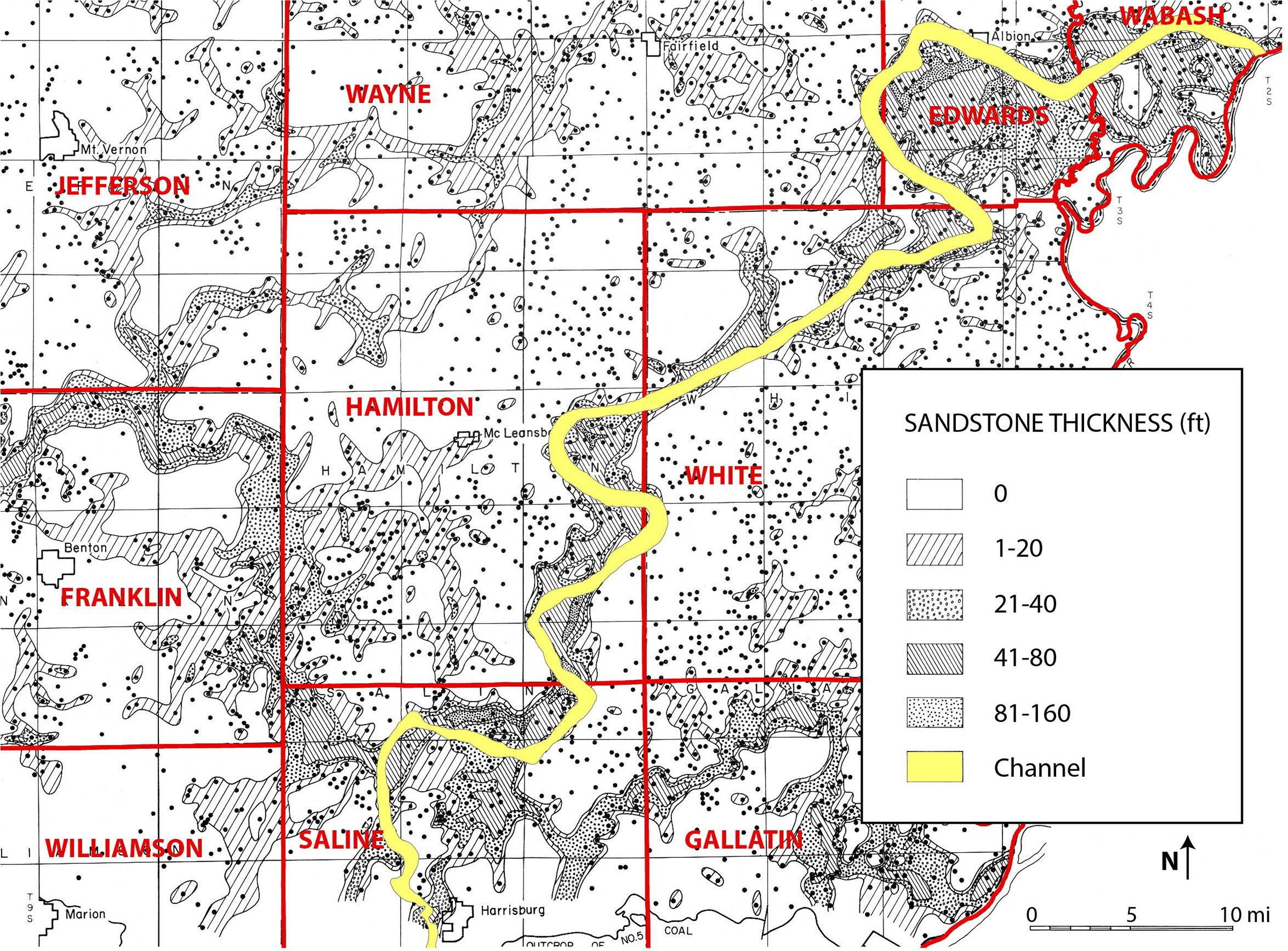 | 2,350 × 1,736 (1.52 MB) | Alan.Myers (talk | contribs) |
You cannot overwrite this file.
File usage
The following 5 pages use this file: