Covel Conglomerate Bed
Lithostratigraphy: Carbondale Formation >>Covel Conglomerate Bed
Chronostratigraphy: Paleozoic Erathem >>Pennsylvanian Subsystem >>Desmoinesian Series
Allostratigraphy: Absaroka Sequence
Primary source
Nelson, W.J., P.H. Heckel and J.M. Obrad, 2022, Pennsylvanian Subsystem in Illinois: Illinois State Geological Survey, Bulletin (in press).
Contributing author(s)
W.J. Nelson
Name
Original description
Willman (1939) fully detailed this unusual limestone conglomerate, which is widely distributed in northern and western Illinois. Kosanke et al. (1960) formally ranked the Covel as a member of the Carbondale Formation.
Derivation
The name comes from Covel Creek, a southern tributary of the Illinois River south of Ottawa in LaSalle County.
Other names
None.
History/background
None.
Type section
Type location
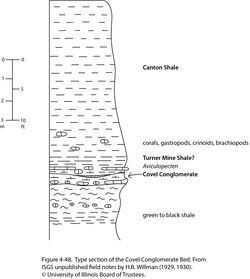
The type section is a high east-facing cut bank of Covel Creek about 2 mi (3 km) south of Ottawa, in the SE¼ SE¼ SW¼ sec. 26, T 33 N, R 3 E, LaSalle County, on the Ottawa 7.5' quadrangle. The section is illustrated (Figure 4-48) but has not previously been described in print. As a type section, this leaves much to be desired. Neither Springfield nor Houchin Creek Coal is present; the limestone and dark shale beds are not positively identified. Field notes do not explicitly identify the conglomerate, 1 inch (2.5 cm) thick, as being the Covel Conglomerate.
Type author(s)
The location is from Wanless (1956, 1957). The section description is from unpublished field notes by L.C. Robinson (1929–1930) and H.B. Willman (1929–1935).
Type status
The status is unknown, but this and neighboring banks of Covel Creek have good prospects for longevity.
Reference section
Reference location
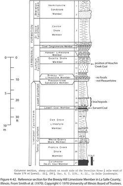
South bank of the Vermilion River ¼ mi (400 m) west of Rt. 178 at Lowell; SE¼ SW¼ sec. 8, T 32 N, R 2 E, LaSalle County (Figure 4-42). This is also a reference section for the Breezy Hill Limestone. Although the Springfield and Houchin Creek Coals are not present, the Turner Mine and Excello Shale Members are represented, so the position of the Covel is well constrained.
Reference author(s)
Smith et al. (1970, p. 24–25) and Trask (1987, p. 224–225) both illustrated and described this section.
Reference status
Not verified.
Stratigraphic relationships
The Covel occurs directly below or a short distance below the underclay of the Springfield Coal and variably overlies the Delafield, Hanover Limestone, Excello Shale, or Houchin Creek Coal Member. Considering its thin, discontinuous nature, the unit is hereby revised to the Covel Conglomerate Bed. This demotion allows for future naming of a member that includes the conglomerate as a basal bed.
Extent and thickness
This lenticular unit normally ranges from a fraction of an inch (centimeter) to about 6 in. (1 to 15 cm) thick. The maximum reported thickness is about 2 ft (60 cm). Outcrops occur chiefly in Fulton, Knox, LaSalle, and Peoria Counties of northern and western Illinois. Wanless (1939, 1957) and other authors alluded to outcrops near Danville, Illinois, and in Indiana and south-central Iowa, but details are not available.
Lithology
The Covel is a limestone–pebble conglomerate. Clasts are mostly coarse sand to pebble size but range up to small cobbles (6 in., 15 cm) and consist of light gray to black micritic limestone. Some clasts are argillaceous, sandy, internally fractured, and partly phosphatized. Shapes are irregular, commonly knobby, but rounded; pebbles “resemble water-worn particles from nodular or concretionary limestone” (Nance 1970, p. 77). Other clasts consist of mudstone or siltstone. The matrix is largely sand-size limestone grains, but well-rounded and frosted quartz sand grains similar to those of the Ordovician St. Peter Sandstone occur at some outcrops. Micrite, sparry calcite, and finely crystalline pyrite fill void space (Willman 1939; Willman and Payne 1942; Wanless 1957; Nance 1970). Accompanying the conglomerate at some outcrops are lenses of nonfossiliferous, micritic limestone as thick as 6 in. (15 cm) and as long as 5 ft (1.5 m). Also present are large spheroidal carbonate concretions and thin layers of limestone that have a cone-in-cone structure (Willman and Payne 1942). Stromatolitic algal crusts have been observed at some localities.
Core(s)
Photograph(s)
Contacts
The lower contact is erosive, whereas the upper contact is sharp and uneven.
Well log characteristics
This unit is unknown in the subsurface.
Fossils
A variety of marine fossils, mostly broken and water worn, have been listed. They include crinoids, gastropods, pelecypods, trilobites, conodonts, shark teeth, and stromatolitic algal crusts (Willman 1939; Nance 1970).
Age and correlation
The Covel may correspond to the upper limestone bed of the Blackjack Creek Limestone in the Midcontinent. The Blackjack Creek commonly comprises distinct upper and lower limestone beds separated by shale (Jewett 1945; Searight and Howe 1961; Gentile 1976; Gentile and Thompson 2004). The lower Blackjack Creek is dense, massive, well-jointed limestone that contains a diverse marine fauna and directly overlies the Excello Shale. The middle shale is 2 to 7 ft (0.6 to 2.1 m), thick, soft, and gray, containing small limestone nodules in the upper part. The thin, discontinuous upper Blackjack Creek Limestone tends to be nodular, and in places it is reduced to isolated nodules in a mudstone matrix. Fossils include ostracods, brachiopods, and the sponge Chaetetes. Heckel (2013, p. 18) wrote, “The upper more conodont-rich bed of the Blackjack Creek Limestone, extending into the lower Morgan School Shale in Iowa, represents a minor transgression. Final regression is recorded in the calcarenitic top of the Blackjack Creek limestone and overlying underclay of the Summit [Springfield equivalent] Coal, which extends southward to the Kansas–Oklahoma border.”
An alternative hypothesis is that the Covel is the basal bed of the Galatia Member, which fills valleys eroded downward from just below the Springfield Coal.
Environments of deposition
Previous authors were rather vague in discussing the origin of this distinctive bed. Judging by the composition, shape, and rounding of clasts, Willman (1939) concluded that they were not intraformational but had not been transported very far. Nance (1970, p. 77) wrote, “The nature of the grains and the algal encrustations indicate a marginal marine environment, and the algal laminations may be tidal features. Most of the limestone particles may have been derived from a more brackish or fresh water environment.” In an abstract, Weibel (2005) offered, “The lithology, texture, and sorting of the clasts and the general absence of internal bedding suggest very rapid deposition in a high-energy environment. Possible environments include low-latitude storm, earthquake-induced tsunami, or impact-induced tsunami. An alternative explanation is that the conglomerate is a transgressive lag deposited during the initial sedimentation of the St. David cyclothem.” Clearly, the Covel reflects a brief advance of the sea into western Illinois—most likely, the minor upper Blackjack Creek transgressive event. Normal tidal-flat and wave-driven processes (including storms) seem more likely than a catastrophic event such as a tsunami.
Economic importance
None.
Remarks
References
- Gentile, R.J., 1976, The geology of Bates County, Missouri: Missouri Geological Survey, Report of Investigations 59, 89 p.
- Gentile, R.J., and T.L. Thompson, 2004, Paleozoic succession in Missouri, Part 5, Pennsylvanian Subsystem, Volume A, Morrowan strata through Cherokee Group: Missouri Geological Survey, Report of Investigations 70, 241 p. and correlation chart.
- Heckel, P.H., 2013, Pennsylvanian stratigraphy of Northern Midcontinent Shelf and biostratigraphic correlation of cyclothems: Stratigraphy, v. 10, nos. 1–2, p. 3–39.
- Jewett, J.M., 1945, Stratigraphy of the Marmaton group, Pennsylvanian, in Kansas: Kansas Geological Survey, Bulletin 58, 148 p.
- Kosanke, R.M., J.A. Simon, H.R. Wanless, and H.B. Willman, 1960, Classification of the Pennsylvanian strata of Illinois: Illinois State Geological Survey, Report of Investigations 214, 84 p. and 1 pl.
- Nance, R.B., 1970, Limestones and phosphatic rocks from the Summum and Liverpool cyclothems in western Illinois: Illinois State Geological Survey, Guidebook Series 8, p. 75–83.
- Searight, W.V., and W.B. Howe, 1961, Pennsylvanian System, in W.B. Howe and J.W. Koenig, eds., The stratigraphic succession in Missouri: Missouri Geological Survey, v. 40, 2nd Series, p. 78–122.
- Smith, W.H., R.B. Nance, M.E. Hopkins, R.G. Johnson, and C.W. Shabica, eds., 1970, Depositional environments in parts of the Carbondale Formation—western and northern Illinois: Francis Creek Shale and associated strata and Mazon Creek biota: Illinois State Geological Survey, Guidebook Series No. 8, 125 p.
- Trask, C.B., 1987, Cyclothems in the Carbondale Formation (Pennsylvanian, Desmoinesian Series) of La Salle County, Illinois: Geological Society of America, Centennial Field Guide, Vol. 3, North-Central Section, p. 221–226.
- Wanless, H.R., 1939, Pennsylvanian correlations in the Eastern Interior and Appalachian coal fields: Geological Society of America, Special Paper 17, 130 p.
- Wanless, H.R., 1956, Classification of the Pennsylvanian rocks of Illinois as of 1956: Illinois State Geological Survey, Circular 217, 14 p.
- Wanless, H.R., 1957, Geology and mineral resources of the Beardstown, Glasford, Havana, and Vermont Quadrangles: Illinois State Geological Survey, Bulletin 82, 233 p.
- Weibel, C.P., 2005, Covel conglomerate from La Salle County (IL): An Upper Carboniferous tempestite or transgressive lag deposit? Geological Society of America, Abstracts with Programs, v. 37, no. 5, p. 79.
- Willman, H.B., 1939, The Covel Conglomerate, a guide bed in the Pennsylvanian of northern Illinois: Illinois Academy of Sciences Transactions, v. 32, p. 174–176.
- Willman, H.B., and J.N. Payne, 1942, Geology and mineral resources of the Marseilles, Ottawa, and Streator Quadrangles: Illinois State Geological Survey, Bulletin 66, 388 p., 29 pls.
ISGS Codes
| Stratigraphic Code | Geo Unit Designation |
|---|---|

