Caseyville Formation
Lithostratigraphy: McCormick Group >>Caseyville Formation
Chronostratigraphy: Paleozoic Erathem >>Pennsylvanian Subsystem >>Morrowan Series
Allostratigraphy: Absaroka Sequence
Primary source
Willman, H. B., Elwood Atherton, T. C. Buschbach, Charles Collinson, John C. Frye, M. E. Hopkins, Jerry A. Lineback, and Jack A. Simon, 1975, Handbook of Illinois Stratigraphy: Illinois State Geological Survey Bulletin 95, 261 p.
Contributing author(s)
M. E. Hopkins and J. A. Simon
Name
Original description
The Caseyville Formation of the McCormick Group (Owen, 1856, p. 48).
Derivation
Named for Caseyville, on the Ohio River in southwestern Union County, Kentucky.
Other names
History/background
Type section
Type location
The type locality is "measured from outcrops on the Illinois shore of the Ohio River between the mouth of the Saline River and Gentry's Landing below Battery Rock," in Hardin County (Lee, 1916, p. 15-16). A well exposed reference section has been described along the Illinois Central Gulf Railroad in Pope County (NW SW SE 31, 11S-5E to NE SE NE 18, 12S-5E) (Kosanke et al., 1960, p. 28, 61-62).
Type author(s)
Type status
Reference section
Reference location
Reference author(s)
Reference status
Stratigraphic relationships
The Caseyville includes strata from the base of the Pennsylvanian to the top of the Pounds Sandstone Member. The top of the Pounds is generally difficult to recognize in the subsurface north of its outcrop.
Extent and thickness
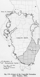
The Caseyville Formation is widespread in southern Illinois, and rocks of similar age have been reported in northwestern Illinois in parts of Mercer and Rock Island Counties (fig. P-9). In southern Illinois the Caseyville Formation is as much as 500 feet thick, but 350 feet is a common maximum elsewhere. The Caseyville varies abruptly in thickness because the unconformable surface on which it was deposited has a relief of a few hundred feet-- from the bottom of large valleys to the flat upland divides (Siever, 1951; Wanless, 1955; Bristol and Howard, 1971). To the north the Caseyville thins to zero and is overlapped by the Abbott Formation (fig. P-9). In Mercer and Rock Island Counties, the formation varies in thickness; it locally exceeds 100 feet.
Lithology
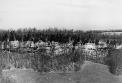
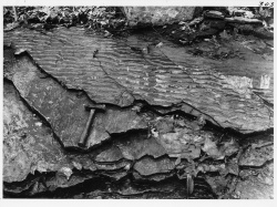
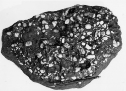
The Caseyville Formation is primarily sandstone (fig. P-3A), siltstone, and shale. The sandstones are composed of quartz and very little clay or mica. Most contain quartz granules and pebbles, commonly less than half an inch (12 mm) in diameter, which occur either scattered throughout the sandstone or concentrated in beds of conglomerate (fig. P-3F). The coarser sandstones reach about 100 feet thick and show relatively uniform cross-bedding with dip directions to the west, south, or southwest (Potter and Olsen, 1954; Potter, 1962b, 1963) parallel to the direction of elongation of the sandstone bodies. In the finer grained sandstone units, which are usually less than 25 feet thick, the most prevalent sedimentary structure is ripple bedding (fig. P-3E). Shale or siltstone interbeds are common. Considerable oil has been produced for many years in the La Salle Anticlinal Belt in eastern Illinois from sandstones in the Caseyville.
The shales and siltstones are not as widely exposed. The thicker shale units in the Lusk and Drury Members are sandy and contain several beds of sandstone, some relatively coarse grained. A few shales associated with coals are dark, relatively fine and uniform, and their clay mineral content is high. Most of the Caseyville in northwestern Illinois is composed of medium gray to dark gray brittle shales interbedded with silty shales and a few clean quartz sandstones.
Several coal seams, most of them somewhat lenticular, are found in the Caseyville Formation, although only one -- the Gentry Coal Member in southeastern Illinois -- is named. In Rock Island and Mercer Counties, as many as seven impure coals up to 2 feet thick occur in the Caseyville (Searight and Smith, 1969).
Limestones are rare in the Caseyville Formation, the only one named being the Sellers Limestone Member, which is exposed in only one small area along the Ohio River Valley. Marine invertebrate fossils are found in this limestone, as well as in a few calcareous sandstone units, some of which contain reworked Mississippian fossils. The formation is otherwise barren of animal fossils.
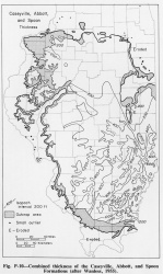
The upper limit of the Caseyville, which is the top of the Pounds Sandstone Member, is commonly difficult to recognize in the subsurface north of its outcrop belt. Consequently, no separate map of the Caseyville thickness was prepared, but figure P-10 shows the combined thickness of the Caseyville, Abbott, and Spoon Formations. Included are strata from the base of the Pennsylvanian up to the base of the Colchester (No. 2) Coal, a widely recognized key member that has been traced throughout the state.
Core(s)
Photograph(s)
Contacts
Well log characteristics
Fossils
Age and correlation
The Caseyville of Illinois correlates with all but the upper few feet of the Caseyville Formation of western Kentucky and with the lower part of the Mansfield Formation of Indiana.
Environments of deposition
Economic importance
Remarks
References
BRISTOL, H. M., and R. H. HOWARD, 1971, Paleogeologic map of the sub-Pennsylvanian Chesterian (upper Mississippian) surface in the Illinois Basin: Illinois State Geological Survey Circular 458, 14 p.
KOSANKE, R. M., J. A. SIMON, H. R. WANLESS, and H. B. WILLMAN, 1960, Classification of the Pennsylvanian strata of Illinois: Illinois State Geological Survey Report of Investigations 214, 84 p.
LEE, WALLACE, 1916, Geology of the Shawneetown quadrangle in Kentucky: Kentucky Geological Survey Bulletin, Series 4, v. 4, part 2, 73 p.
OWEN, D. D., 1856, Report of the geological survey in Kentucky made during the years 1854 and 1855: Kentucky Geological Survey Bulletin, v. I, Series 1, 416 p.
POTTER, P. E., 1962b, Shape and distribution patterns of Pennsylvanian sand bodies in Illinois: Illinois State Geological Survey Circular 339, 35 p.
POTTER, P. E., 1963, Late Paleozoic sandstones of the Illinois Basin: Illinois State Geological Survey Report of Investigations 217, 92 p.
POTTER, P. E., and J. S. OLSON, 1954, Variance components of cross-bedding direction in some basal Pennsylvanian sandstones of the Eastern Interior Basin-geological application: Journal of Geology, v. 62, p. 50-73.
SEARIGHT, T. K., and W. H. SMITH, 1969, Strippable coal reserves of Illinois, Part 5B: Illinois State Geological Survey Circular 439, 22 p.
SIEVER, RAYMOND, 1951, Mississippian-Pennsylvanian unconformity in southern Illinois: American Association of Petroleum Geologists Bulletin, v. 35, p. 542-581; Illinois State Geological Survey Report of Investigations 152.
WANLESS, H. R., 1955, Pennsylvanian rocks of Eastern Interior Basin: American Association of Petroleum Geologists Bulletin, v. 39, p. 1753-1820 (see 1962).
WANLESS, H. R., 1962, Pennsylvanian rocks of Eastern Interior Basin, in Pennsylvanian System in the United States- A symposium: American Association of Petroleum Geologists. Originally published 1955; reprinted with minor revisions.
ISGS Codes
| Stratigraphic Code | Geo Unit Designation |
|---|---|
