Banner Formation
Lithostratigraphy: Banner Formation
Chronostratigraphy: Cenozoic Erathem >>Quaternary System >>Pleistocene Series
Primary source
Willman, H. B., and John C. Frye, 1970, Pleistocene Stratigraphy of Illinois: Illinois State Geological Survey Bulletin 94, 204 p.
Contributing author(s)
H. B. Willman and John C. Frye
Name
Original description
Banner Formation (Willman and Frye 1970).
Derivation
The Banner Formation is named for Banner, Fulton County, Illinois.
Other names
In previous reports the Banner Formation has been called Kansan till, Kansan drift, or pre-Illinoian drift (Cady, 1919; MacClintock, 1926, 1929, 1933; Wanless, 1929a, 1957; Horberg, 1953, 1956; Willman, Glass, and Frye, 1963; Johnson, 1964; Jacobs and Lineback, 1969; and others).
History/background
Type section
Type location
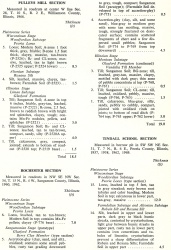
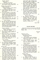
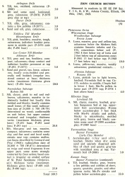
The type section for the Banner Formation is taken from exposures in the Tindall School Section (table 6), a large borrow pit in the Illinois Valley bluff, SW SW NE Sec. 31, T. 7 N., R. 6 E., Peoria County.
| Table 6 -- Stratigraphic Sections (partial) The following 21 stratigraphic sections describe exposures in Illinois and illustrate many of the aspects of Pleistocene stratigraphy. These sections contain the type localities for 21 rock-stratigraphic units, 4 soil-stratigraphic units, and 3 time-stratigraphic units and include paratypes for several other units. The sample numbers preceded by "P" are the numbers used in the Illinois State Geological Survey collections. Analytical data on many of these samples are on file at the Survey. The sections are arrange alphabetically by name. |
Type author(s)
Type status
Reference section
Reference location
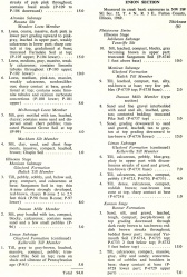
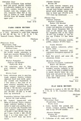
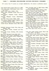
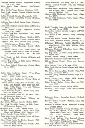
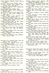
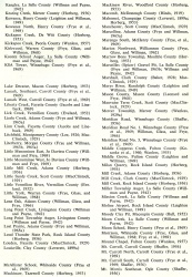
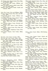
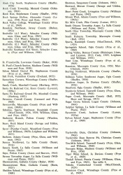
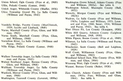
In addition to the Tindall School Section, the Banner Formation is described in the Enion and Zion Church Sections (table 6). Other significant sections of the Banner Formation in western Illinois include the Big Creek, Big Sister Creek, Independence School, Little Mill Creek, Mill Creek (Adams County), Mill Creek (Rock Island County), and Pryor School (table 7). Representative sections of the Banner Formation of east-central Illinois are the Georgetown School, Jewett, Petersburg Dam, Rock Creek Township, Taylorville Dam, and Vandalia Bridge Sections (table 7).
| Table 6 -- Stratigraphic Sections (partial) The following 21 stratigraphic sections describe exposures in Illinois and illustrate many of the aspects of Pleistocene stratigraphy. These sections contain the type localities for 21 rock-stratigraphic units, 4 soil-stratigraphic units, and 3 time-stratigraphic units and include paratypes for several other units. The sample numbers preceded by "P" are the numbers used in the Illinois State Geological Survey collections. Analytical data on many of these samples are on file at the Survey. The sections are arrange alphabetically by name. |
|
Reference author(s)
Reference status
Stratigraphic relationships
The Banner Formation includes the glacial tills and intercalated outwash of sand, gravel, and silt overlying the Enion Formation or the Afton Soil. It is bounded at the top by the Petersburg, Loveland, Pearl, or Glasford Formations or the top of the Yarmouth Soil. At many places it rests directly on bedrock.
The bulk of the Banner Formation is not subdivided into members, but in western Illinois the Harkness Silt Member occurs at the base and the accretion-gley at the top is the Lierle Clay Member. In central Illinois two members are recognized that occur largely in the subsurface as outwash filling earlier valleys -- the Sankoty Sand Member and the Mahomet Sand Member.
In western Illinois fossiliferous silt within the till (Tindall School Section, table 6) has not been found widely enough to justify differentiation as a member. Johnson, Gross, and Moran (in press) differentiated three members in the Banner Formation in the Danville region, Vermilion County.
| Table 6 -- Stratigraphic Sections (partial) The following 21 stratigraphic sections describe exposures in Illinois and illustrate many of the aspects of Pleistocene stratigraphy. These sections contain the type localities for 21 rock-stratigraphic units, 4 soil-stratigraphic units, and 3 time-stratigraphic units and include paratypes for several other units. The sample numbers preceded by "P" are the numbers used in the Illinois State Geological Survey collections. Analytical data on many of these samples are on file at the Survey. The sections are arrange alphabetically by name. |
|
Extent and thickness
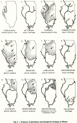
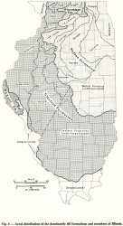
The Banner Formation is defined on the basis of its occurrence in western Illinois, but the geographically separate and stratigraphically equivalent deposits elsewhere in Illinois are also included within the formation. The geographic extent of the Banner Formation where it is the surface drift is shown in figure 6, but in the subsurface it is present locally throughout much of western, central, and eastern Illinois in the area covered by the Kansan glaciers (fig. 5). The formation is as much as 300 feet thick where it fills deep valleys in the bedrock, but it was entirely removed by glacial erosion throughout large areas.
Lithology
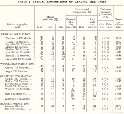
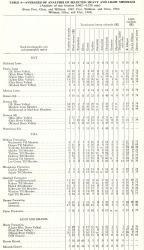
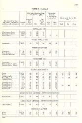
Clay mineral data for the Banner Formation of western Illinois are given in table 5 and averages of heavy and light mineral analysis in table 4. The strong contrast in typical clay mineral composition and garnet-epidote ratios between the western and eastern areas of the Banner Formation are shown by table 2. General compositional data have been published (Willman, Glass, and Frye, 1963, 1966; Johnson, 1964; Jacobs and Lineback, 1969; Frye, Willman, and Glass, 1964).
|
In western Illinois the till of the Banner Formation can be distinguished from the overlying tills of the Glasford Formation by its much higher content of expandable clay minerals, lower ratio of garnet to epidote, and higher ratio of calcite to dolomite, in addition to its stratigraphic position. In east-central Illinois, the clay mineral composition of the till of the Banner Formation falls within the range of that of the overlying Glasford Formation tills, although it is generally somewhat higher in kaolinite and chlorite and lower in expandable clay minerals; the Banner also differs from the Glasford in its higher garnet to epidote ratio and its much higher ratio of calcite to dolomite.
Core(s)
Photograph(s)
Contacts
Well log characteristics
Fossils
Age and correlation
The Banner Formation extends through the Kansan and Yarmouthian Stages.
Environments of deposition
The deposits are largely the result of glacial advances into Illinois from the northwest and from the northeast.
Economic importance
Remarks
References
CADY, G. H., 1919, Geology and mineral resources of the Hennepin and La Salle Quadrangles: Illinois State Geological Survey Bulletin 37, 136 p.
FRYE, J. C., H. B. WILLMAN, and H. D. GLASS, 1964, Cretaceous deposits and the Illinoian glacial boundary in western Illinois: Illinois State Geological Survey Circular 364, p. 28.
HORBERG, C. L., 1953, Pleistocene deposits below the Wisconsin drift in northeastern Illinois: Illinois State Geological Survey Report of Investigations 165, 61 p.
HORBERG, C. L., 1956, Pleistocene deposits along the Mississippi Valley in central western Illinois: Illinois State Geological Survey Report of Investigations 192, 39 p.
JACOBS, A. M., and J. A. LINEBACK, 1969, Glacial geology of the Vandalia, Illinois, region: Illinois State Geological Survey Circular 442, 24 p.
JOHNSON, W. H., 1964, Stratigraphy and petrography of Illinoian and Kansan drift in central Illinois: Illinois State Geological Survey Circular 378, 38 p.
MacCLINTOCK, PAUL, 1926, Pre-Illinoian till in southern Illinois: Journal of Geology, v. 34, no. 2, p. 175-180.
MacCLINTOCK, PAUL, 1929, I. Physiographic divisions of the area covered by the Illinoian drift-sheet in southern Illinois. II. Recent discoveries of pre-Illinoian drift in southern Illinois: Illinois State Geological Survey Report of Investigations 19, 57 p.
MacCLINTOCK, PAUL, 1933, Correlation of the pre-Illinoian drifts of Illinois: Journal of Geology, v. 41, no. 7, p. 710-722.
WANLESS, H. R., 1929a, Geology and mineral resources of the Alexis Quadrangle: Illinois State Geological Survey Bulletin 57, 230 p.
WANLESS, H. R., 1957, Geology and mineral resources of the Beardstown, Glasford, Havana, and Vermont Quadrangles: Illinois State Geological Survey Bulletin 82, 233 p.
WILLMAN, H. B., H. D. GLASS, and J. C. FRYE, 1963, Mineralogy of Glacial Tills and Their Weathering Profiles in Illinois, Part 1—Glacial Tills: Illinois State Geological Survey Circular 347, 55 p.
WILLMAN, H. B., H. D. GLASS, and J. C. FRYE, 1966, Mineralogy of glacial tills and their weathering profiles in Illinois. Part II—Weathering profiles: Illinois State Geological Survey Circular 400, 76 p.
ISGS Codes
| Stratigraphic Code | Geo Unit Designation |
|---|---|
