Anna Shale Member
Lithostratigraphy: Carbondale Formation >>Anna Shale Member
Chronostratigraphy: Paleozoic Erathem >>Pennsylvanian Subsystem >>Desmoinesian Series
Allostratigraphy: Absaroka Sequence
Primary source
Nelson, W.J., P.H. Heckel and J.M. Obrad, 2022, Pennsylvanian Subsystem in Illinois: Illinois State Geological Survey, Bulletin (in press).
Contributing author(s)
W.J. Nelson
Name
Original description
Jewett (1941, p. 316) wrote that “the Anna shale includes in ascending order (1) local thin, dark, slabby limestone and (2) black, platy and locally fissile shale.” Jewett (1945) elaborated further on characteristics of this unit. First to use the name Anna Shale in Illinois was Tubb (1961), followed by Wanless et al. (1963).
Derivation
The name refers to the town of Anna, now Pawnee Station, southwest of Fort Scott in Bourbon County, Kansas. Anna formerly had a post office but is unincorporated today. The name may be derived from Anna Barton (1827–1919), whose husband George ran a store in town (www.findagrave.com/memorial/43921903/anna-amelia-barton).
Other names
None.
History/background
See above.
Type section
Type location
Jewett (1941) gave slightly conflicting locations of the section. Following a lead from P.H. Heckel, Gentile and Thompson (2004) located the section less than 2 mi (3 km) west of Pawnee Station along State Rt. 7 just south of the center of sec. 7, T 27 S, R 24 E, Bourbon County, Kansas.
Type author(s)
Jewett (1941); Gentile and Thompson (2004).
Type status
Unknown.
Reference section
Reference location
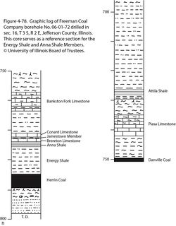
Gentile and Thompson (2004) described and illustrated four reference sections in Missouri. For Illinois, core from Freeman Coal Company borehole #06-01-72 is hereby offered. The hole was drilled in sec. 16, T 3 S, R 2 E, Jefferson County, ISGS county no. 2786. The Anna Shale is 1.9 ft (58 cm) thick and occupies the depth interval from 773.6 to 775.5 ft (235.8 to 236.4 m; Figure 4-78). This core also serves as the reference section for the Energy Shale.
Reference author(s)
This report.
Reference status
Logs from #06-01-72 are on file in the Coal Section of the ISGS. Core is archived at the ISGS Geological Samples Library in Champaign under call number C-8768.
Stratigraphic relationships
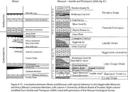
In Kansas and Missouri, the Anna Shale overlies the Lexington Coal (Herrin equivalent) and underlies the Myrick Station Limestone, a Brereton equivalent (Figure 4-72). First proposed by Wanless (1939), these correlations subsequently have been confirmed via multiple lines of evidence. In Illinois, the Anna overlies the Herrin Coal, or its horizon, and onlaps the Energy Shale. Above the Anna Shale is the Brereton Limestone Member and various younger members of the Shelburn Formation.
Extent and thickness
The Anna Shale is more or less coextensive with the Herrin Coal. In the deeper part of the basin, the Anna varies from a few inches to 5 ft (1.5 m) thick, locally reaching 10 ft (3 m). Willman and Payne (1942, p. 134) reported a thickness as great as 14 ft (4.2 m) in LaSalle County, northern Illinois. Mapping in underground mines on the Western Shelf shows that the Anna can be highly lenticular. Pods of Anna are irregular in map view and are typically several tens to hundreds of feet (~10 to 100 m) across. Where the Anna is absent, the Brereton Limestone or, occasionally, younger units lie directly on the Herrin Coal (Krausse et al. 1979; Nelson et al. 1987). This lenticular pattern is unusual among Pennsylvanian black shale units and presents a problem in interpretation.
Lithology
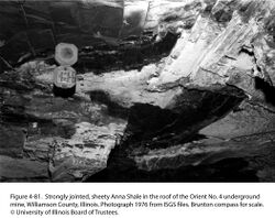
For the most part, the Anna is typical Pennsylvanian black shale: jet-black, finely silty to silt free, hard and brittle, and highly fissile, commonly described as sheety or slaty. Dolomitic septarian concretions a foot or more (30 cm) in diameter are common. Prominent sets of planar, parallel joints are developed (Figure 4-81). Where the Anna is thin on the Western Shelf, its entire thickness tends to be hard and sheety. Where the shale is thicker than 1 or 2 ft (30 to 60 cm), two subunits are commonly present. The lower subunit is black, hard, and sheety, whereas the upper subunit is mottled, weakly fissile, softer, and less competent. Colors are shades of dark gray, greenish gray, and olive gray. Mottling follows a network of fractures that outline polygons and form a mosaic or patchwork pattern. The mottled portion contains bands of phosphatic laminae and lenses and lacks septarian concretions (Krausse et al. 1979).
Lenses of grayish black, impure limestone (informally called “bastard limestone”) locally occur at the base of the Anna. They contain a “hash” of broken fossils, commonly replaced by pyrite. In some cases, the limestone fills small rolls eroded into the top of the Herrin Coal (Bauer and DeMaris 1982). A similar black basal limestone is present in Kansas (Jewett 1941, 1945).
Core(s)
Photograph(s)
Contacts
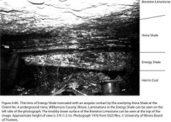
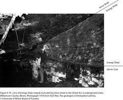
The lower contact is generally sharp and, in many cases, is definitely erosional. Bauer and DeMaris (1982) documented that the Herrin Coal is thinner under Anna Shale than under the Energy Shale at a mine in southern Illinois, and they attributed the thinning to pre-Anna erosion. Unpublished studies at several other mines confirm this relationship. Where Anna overlies Energy Shale, truncated bedding of the latter often is evident (Figures 4-79 and 4-80).
The contact between Anna Shale and Brereton Limestone appears to grade through a layer about 1 to 6 in. (3 to 15 cm) thick of weak, strongly mottled and burrowed calcareous mudstone that miners call “clod.” However, the lenticular distribution of the Anna and truncation of the upper mottled subunit at the base of the Brereton suggests that the Anna–Brereton contact is erosive. Burrowing and reworking of limy sediment at the onset of carbonate deposition may have obscured the scoured contact.
Well log characteristics
The Anna displays a typical log response for Pennsylvanian black shale, highlighted by “hot” gamma-ray log readings. The “hot” gamma-ray spike has been observed in boreholes where coring shows the Anna is mottled shale only a few inches (<10 cm) thick.
Fossils
The sparse fauna includes Lingula, Orbiculoidea, Pteria, Pleurophorella, pectenoid pelecypods, cephalopods, conodonts, serpulid worms, sharks, and bony fishes. Fossils in the basal lenticular limestone are difficult to identify, but these include articulate brachiopods, bivalves, and gastropods (Grenda 1966; Bauer and DeMaris 1982; Palmer et al. 1985; Nelson et al. 1987).
Age and correlation
The original continuity of the Anna throughout the Illinois and Midcontinent Basins appears securely established. There is no corresponding named unit in the Appalachian Basin, but marine shale overlying the Upper Kittanning coal bed is presumed to be an Anna equivalent.
Environments of deposition
For the most part, the Anna Shale fits the general model for black shale deposition. The localized basal limestone was a product of the rapid initial transgression before fully anoxic conditions were established. On the Western Shelf, partial ocean circulation was reestablished during the later stages of Anna deposition, producing the mottled, nonfissile subunit. Widespread erosion followed, producing a patchy local distribution of black shale. Visualizing this type of shale deposited in a series of shallow isolated pools is difficult.
Economic importance
None, aside from serving as an immediate roof in many underground mines.
Remarks
References
- Bauer, R.A., and P.J. DeMaris, 1982, Geologic investigation of roof and floor strata, longwall demonstration, Old Ben Mine No. 24: Illinois State Geological Survey, Contract/Grant Report 1982-2, 49 p.
- Gentile, R.J., and T.L. Thompson, 2004, Paleozoic succession in Missouri, Part 5, Pennsylvanian Subsystem, Volume A, Morrowan strata through Cherokee Group: Missouri Geological Survey, Report of Investigations 70, 241 p. and correlation chart.
- Grenda, J.C., 1966, Paleontology of two Middle Pennsylvanian black shales in the Brereton and St. David cyclothems of parts of Jackson and Perry counties, Illinois: Carbondale, Southern Illinois University, M.S. thesis, 108 p.
- Jewett, J.M., 1941, Classification of the Marmaton group, Pennsylvanian, in Kansas: Kansas Geological Survey, Bulletin 38, part 2, p. 285–344.
- Jewett, J.M., 1945, Stratigraphy of the Marmaton group, Pennsylvanian, in Kansas: Kansas Geological Survey, Bulletin 58, 148 p.
- Krausse, H.-F., H.H. Damberger, W.J. Nelson, S.R. Hunt, C.T. Ledvina, C.G. Treworgy, and W.A. White, 1979, Roof strata of the Herrin (No. 6) Coal Member in mines of Illinois, their geology and stability: Illinois State Geological Survey, Illinois Minerals Note 72, 54 p.
- Nelson, W.J., P.J. DeMaris, and R.A. Bauer, 1987, The Hornsby district of low-sulfur Herrin Coal in central Illinois (Christian, Macoupin, Montgomery, and Sangamon Counties): Illinois State Geological Survey, Circular 540, 40 p., 1 pl.
- Palmer, J.E., C.B. Trask, and R.J. Jacobson, 1985, Depositional environments of strata of late Desmoinesian age overlying the Herrin (No. 6) Coal in southwestern Illinois and the occurrence of low-sulfur coal, in A.T. Cross, ed., Economic geology: Coal, oil and gas: Ninth International Congress of Carboniferous Geology and Stratigraphy, Proceedings, v. 4: Carbondale, Southern Illinois University Press, p. 329–341.
- Tubb, J.B., Jr., 1961, Environmental study of stages within the Brereton cyclothem of Illinois in the Eastern and part of the Western Interior coal basins: Urbana, University of Illinois, M.S. thesis, 40 p.
- Wanless, H.R., 1939, Pennsylvanian correlations in the Eastern Interior and Appalachian coal fields: Geological Society of America, Special Paper 17, 130 p.
- Wanless, H.R., J.B. Tubb Jr., D.E. Gednetz, and J.L. Weiner, 1963, Mapping sedimentary environments of Pennsylvanian cycles: Geological Society of America Bulletin, v. 74, no. 4, p. 437–486.
- Willman, H.B., and J.N. Payne, 1942, Geology and mineral resources of the Marseilles, Ottawa, and Streator Quadrangles: Illinois State Geological Survey, Bulletin 66, 388 p., 29 pls.
ISGS Codes
| Stratigraphic Code | Geo Unit Designation |
|---|---|
