Category:Producing Zones and Informal Names: Difference between revisions
mNo edit summary |
Alan.Myers (talk | contribs) No edit summary |
||
| (9 intermediate revisions by 2 users not shown) | |||
| Line 1: | Line 1: | ||
The graphic below shows a generalized geologic column of southern Illinois with formal stratigraphic Formation names in all capital letters, and oil producing zones and informal names in red. Information on the oil producing zones and informal names in Illinois shown on this graphic can be found by clicking on their corresponding names on the image, or in the alphabetical listing of names below the geologic column. Both links go to the '''Economic importance''' section of the corresponding formal geologic unit.<br> | |||
For example – the 'Ohara' oil producing zone can be found on the geologic column within the Ste. Genevieve, and in the alphabetical listing below. Clicking on either will go to the '''Economic importance''' section of the geologic unit that the ‘Ohara’ resides within. In this case the text for that section is as follows: “'Ohara' is an informal name applied to producing zones in the Karnak Limestone Member of the Ste. Genevieve Limestone.” This means that the 'Ohara' oil producing zone is found within the Karnak Limestone Member, which is within the Ste. Genevieve Limestone (Formation).<br> | |||
Not all oil producing zones and informal names have Member level designations, but all have Formation level designations. <br> | |||
For example the 'Benoist' oil producing zone reads as follows: “'Benoist' is an informal name applied to producing zones in the Yankeetown Sandstone”. This means that the 'Benoist' oil producing zone is found within the Yankeetown Sandstone (Formation).<br> | |||
<br> | |||
[https://ilstratwiki.web.illinois.edu/images/2/29/Producing_Zones_and_Informal_Names_Lookup_Table.pdf Producing Zones and Informal Names Lookup Table]<br> | |||
<br> | |||
<imagemap> | <imagemap> | ||
image: GOI-ch15-fig15.jpg|1000px | image: GOI-ch15-fig15.jpg|1000px | ||
| Line 30: | Line 36: | ||
rect 1135 775 1221 822 [[Lingle Formation#Economic importance|Hibbard, Hoing]] | rect 1135 775 1221 822 [[Lingle Formation#Economic importance|Hibbard, Hoing]] | ||
rect 1137 841 1269 888 [[Grand Tower Limestone#Economic importance|Geneva, Dutch Creek]] | rect 1137 841 1269 888 [[Grand Tower Limestone#Economic importance|Geneva, Dutch Creek]] | ||
rect 1135 981 1333 1008 [[ | rect 1135 981 1333 1008 [[Bailey Limestone#Economic importance|Flat Gap limestone]] | ||
rect 1134 1023 1258 1049 [[Bailey Limestone#Economic importance|Beaucoup]] | rect 1134 1023 1258 1049 [[Bailey Limestone#Economic importance|Beaucoup]] | ||
rect 1137 1068 1328 1093 [[Moccasin Springs Formation#Economic importance|Silurian, Niagaran]] | rect 1137 1068 1328 1093 [[Moccasin Springs Formation#Economic importance|Silurian, Niagaran]] | ||
Latest revision as of 15:20, 29 May 2020
The graphic below shows a generalized geologic column of southern Illinois with formal stratigraphic Formation names in all capital letters, and oil producing zones and informal names in red. Information on the oil producing zones and informal names in Illinois shown on this graphic can be found by clicking on their corresponding names on the image, or in the alphabetical listing of names below the geologic column. Both links go to the Economic importance section of the corresponding formal geologic unit.
For example – the 'Ohara' oil producing zone can be found on the geologic column within the Ste. Genevieve, and in the alphabetical listing below. Clicking on either will go to the Economic importance section of the geologic unit that the ‘Ohara’ resides within. In this case the text for that section is as follows: “'Ohara' is an informal name applied to producing zones in the Karnak Limestone Member of the Ste. Genevieve Limestone.” This means that the 'Ohara' oil producing zone is found within the Karnak Limestone Member, which is within the Ste. Genevieve Limestone (Formation).
Not all oil producing zones and informal names have Member level designations, but all have Formation level designations.
For example the 'Benoist' oil producing zone reads as follows: “'Benoist' is an informal name applied to producing zones in the Yankeetown Sandstone”. This means that the 'Benoist' oil producing zone is found within the Yankeetown Sandstone (Formation).
Producing Zones and Informal Names Lookup Table
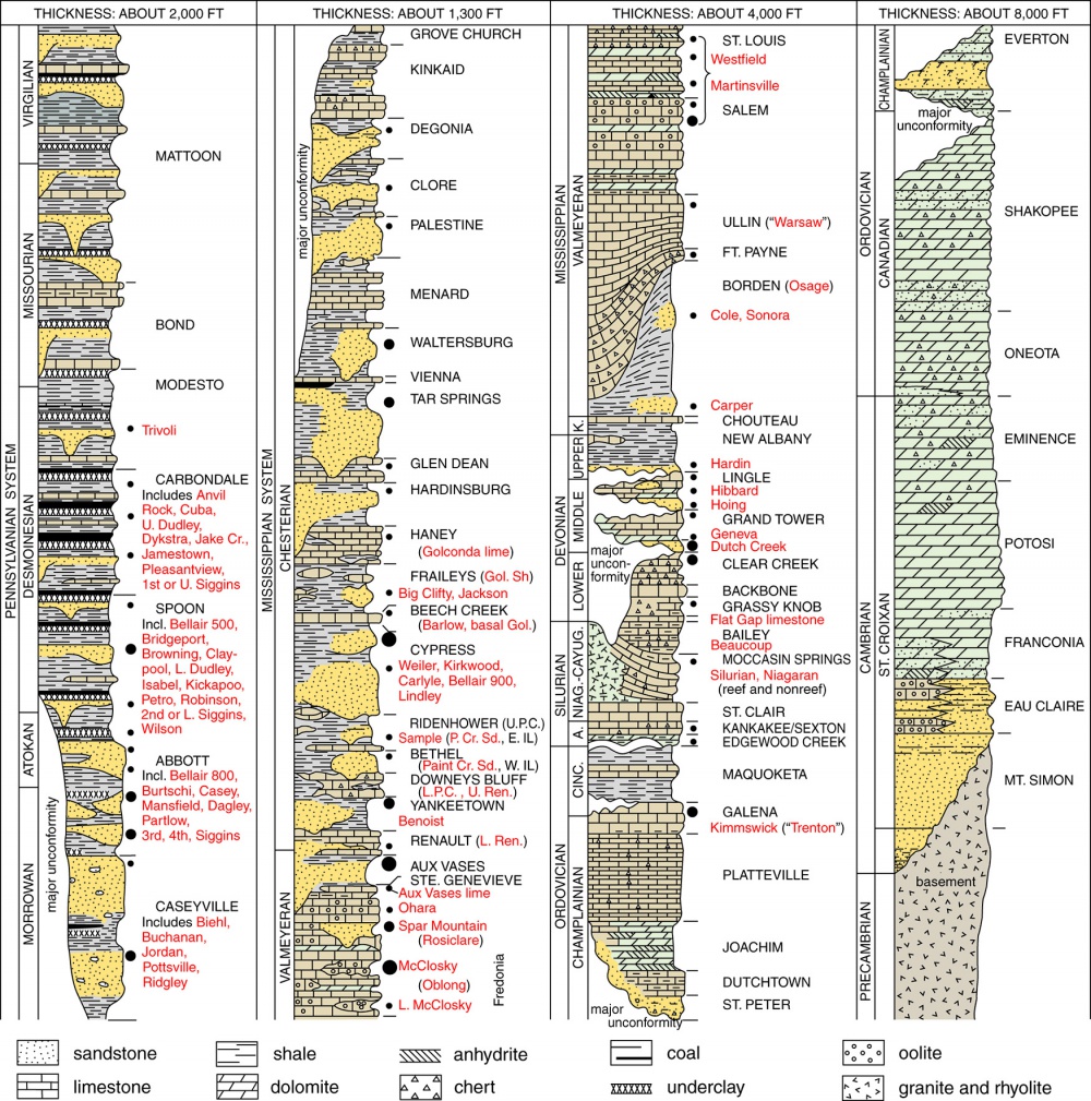

Generalized geological column of southern Illinois. Size of solid dots indicates relative amount of petroleum produced from individual producing zones. Formation names are in capital letters. Abbreviations: A., Alexandrian; Cinc., Cincinnatian; Cr., Creek; E., eastern; Gol., Golconda; Incl., including; K., Kinderhookian; L., lower; Niag.-Cayug., Niagaran-Cayugan; P. Cr. Sd, Paint Creek sand; Ren., Renault; Sh, shale; U., upper; U.P.C., Upper Paint Creek; W., western.
Modified from: Kolata, Dennis R, and Cheryl Nimz, eds., 2010, Geology of Illinois: University of Illinois at Urbana-Champaign, Institute of Natural Resource Sustainability, Illinois State Geological Survey, 530 p.
Pages in category "Producing Zones and Informal Names"
The following 76 pages are in this category, out of 76 total.